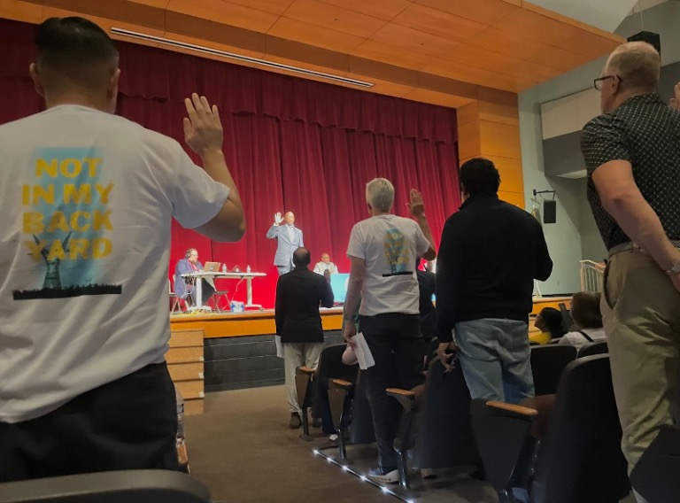
Albemarle County & the City of Charlottesville

The staff in PEC's Charlottesville office works with citizens to solve the many land use and conservation challenges facing the Charlottesville and Albemarle area.
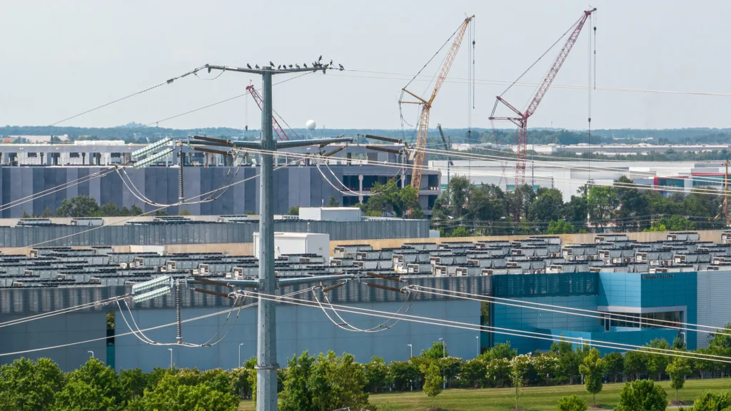
6,315 acres conserved in nine-county region last year

6,315 acres conserved in nine-county region last year

The Piedmont Environmental Council reports that in 2023, 6,315 acres of land in Albemarle, Clarke, Culpeper, Fauquier, Greene, Loudoun, Madison, Orange and Rappahannock counties were permanently protected with 52 new conservation easements.

Albemarle County Rural Area – PEC Interactive Map

Albemarle County Rural Area – PEC Interactive Map

Albemarle County is undergoing an update of its Comprehensive Plan, called AC44 — to serve as a guideline for development and infrastructure in the County over the next 20 years. Given that the maps that depict the wide range of Rural Area resource values are scattered within various County plans and on the County’s GIS platform, PEC has created an interactive map that combines several layers of mapped resources into one. Our interactive map can support community engagement as the County moves through the AC44 Comprehensive Plan update process focusing on major policy goals and objectives.

PEC’s interactive Rural Area map can also support the review of proposed projects within the Rural Area such as utility-scale solar facilities, new electric transmission lines, rural subdivisions, and non-residential land development proposals. PEC has been advocating for strong protections for the values in the Rural Area and smart policies in the Development Area to support this. See our policy recommendations and platform for more information>>

Viewers can use the online “Layer List” found on the right-hand side of the map to see the key and toggle on and off layers of interest.

View our Rural Area map fullscreen>>

PEC developed the interactive Rural Area map to:

  • Provide a spatial representation of the valuable/sensitive/significant characteristics within the Rural Area on a single mapping platform;
  • Support advocating for policies to protect the Rural Area from sprawl and incompatible development; and
  • Support PEC’s high-level recommendation that the County should include a detailed recommendation for the preparation of a Rural Area Plan in the comp plan update.

You can download three PDF maps that include combinations of the map layers listed above:

The interactive map above was created, in part, to contrast the map below — the Generalized Land Use Plan prepared by Albemarle County which is the first map in the County’s 2015 Comprehensive Plan. The Development Areas represent 5% of the County, or 37 square miles, and are identified by the various colors indicating designated areas for housing, commercial development, light-industrial uses, open spaces, and other uses. The Rural Area is approximately 95% of the county, or 689 square miles — it is rendered in white here, making it appear empty.

The Generalized Land Use Plan Map from the 2015 Comprehensive Plan depicts only the Development Areas in color and the Rural Areas in white.

However, we know from the 2015 Comp Plan policy goals, objectives, and strategies for the Rural Area, Natural Resources, Historic, Cultural, and Scenic Resources, and Economic Development that Albemarle County values its natural resources and magnificent cultural landscapes. 

The County’s Rural Area is home to forests and farmland, wildlife habitats and corridors, waterways, orchards, vineyards, and historically and culturally significant properties. These rural lands sustain agricultural and forestry operations that are both economically and ecologically important to local communities and to the region. County residents and visitors prize these special places and important resources alike. Albemarle has substantial areas of conservation and has been a model for sustained local efforts to connect and protect critical resources. These conserved lands also help to maintain the rural character and scenic beauty of the Rural Area, and perhaps most importantly, provide increased resiliency by offsetting some of the most harmful climate impacts. It would be costly and difficult, if not impossible, to restore these important places and resources if we lose them.

Additional Background:

Community Surveys in Albemarle County: Perspectives on Planning, Preservation, and Natural Resources from 1994 to 2023

To better understand how residents value the Rural Area, PEC undertook a review of community surveys conducted in Albemarle County from 1994 to the present focusing on survey responses related to the environment, growth management, natural resources, preservation, and rural areas. The surveys reviewed in our Community Surveys in Albemarle County: Perspectives on Planning, Preservation, and Natural Resources from 1994 to 2023 have historically played a crucial role in shaping strategic plans and comprehensive plans in Albemarle County. The results of our findings identify a longstanding and consistently high commitment to growth management policy, preservation of natural resources, and protection of rural area character. 

The results of our analysis underscore the priority Albemarle County residents have overwhelmingly given to policies tied to the environment, preservation, and smart growth for nearly 30 years. In this time, Albemarle County residents have given high value to policies pertaining to the environment and preservation, access to nature and recreation, reinforcing the pivotal role these themes play in the community’s ethos and direction. 

“Albemarle County’s Development Areas will be attractive, vibrant, areas for residents and businesses, supported by services, facilities, and infrastructure. Growth will be directed to the Development Areas and the County’s Rural Area, with its agricultural, forestal, historic, cultural, scenic, and natural resources, will be preserved for future generations.”

The County’s 2015 Growth Management Policy 

PEC research on the Albemarle County Rural Area Performance Value

The facts gathered were intended to promote a better understanding of Albemarle’s Rural Area with a focus on agriculture, working forests, and ecosystem services. The research reveals a more complete understanding of Albemarle’s Rural Area, why agricultural statistics should be more carefully studied, and expand upon the other values being provided through Rural Area land use and associated industries.

Our research was informed by both publicly available and exchanged information, through ongoing communications with the Virginia Department of Agriculture and Consumer Services, the Virginia Cooperative Extension, USDA 2017 Census of Agriculture (at the time of writing, we relied on the latest USDA Census of Agriculture), local, state, and national grower’s associations including the Virginia Wine Association, USAPPLE Association, Virginia State Horticultural Society, the USDA National Agricultural Statistics Service (NASS), Weldon Cooper Center For Public Service, Virginia Department of Forestry, The Central Virginia Partnership for Economic Development and The Virginia Tourism Corporation. Ecological benefits of land cover and land use data are provided through Chesapeake Tree Canopy Network in cooperation with USGS, Chesapeake Conservancy, the University of Vermont Spatial Analysis Lab, the Chesapeake Bay Program, and information collected from Albemarle County’s websites.

This is what we learned about the County’s Rural Area…

  • Ranked 25th in the Commonwealth for crop production, out of 97 reporting localities.
  • Second highest producing county in Virginia in the fruits/tree nuts/berries category.
  • Third highest producing county in Virginia in the horses/ponies/mules/burros/donkeys category.
  • Produces 21 percent of all grapes harvested for wine production in the Commonwealth. 
  • Produces nearly half of all grapes harvested for wine production in the Central Virginia region.
  • Ranks above the 70 percentile in total cattle count in the Commonwealth for years 2022 and 2023.
  • Ranks 39th out of 110 Virginia localities in the total tax value generated across all timber types, ranked notably high among hardwood timber types.
  • Contributes nearly 12 percent of statewide land devoted to orchards, and to the present remains a key region for fruit trees, in particular apples – a nationally competitive and historically significant contribution to production and the continuity of use. 
  • Leads all Central Virginia counties in the number of people employed in agriculture, forestry, fishing, and hunting combined. The number of people employed in these industries has also increased over a five year period. 
  • $76.3 million annual benefits provided by tree cover (in reduced air pollution, stormwater management, and sequestered carbon dioxide).
  • Total annual air pollution removal value of 20,720 lbs removed annually; $3.0 Million saved annually.
  • Gallons of reduced stormwater runoff value of 287.9 million gallons annually; $2.6 million saved annually.
  • The County’s forests and tree cover sequester nearly a million metric tons of carbon annually.

Special thanks:

This WebMap was created by PEC’s GIS Specialist Watsun Randolph with support from PEC’s Rob McGinnis, Kim Biasiolli, and Faith Schweikert. Questions? Contact Rob at rmcginnis@pecva.org.

Albemarle County AC44 Comprehensive Plan Rural Area Land Use & Transportation Goals & Objectives: Suggested Talking Points | 23 Feb. 2024

Albemarle County AC44 Comprehensive Plan Rural Area Land Use & Transportation Goals & Objectives: Suggested Talking Points | 23 Feb. 2024

Contact: Rob McGinnis – rmcginnis@pecva.org, (434) 962-9110

The following are PEC’s recommendations for the Rural Area Land Use & Transportation draft Goals & Objectives, which will be presented to the Albemarle County Planning Commission Tues, Feb. 27.


Rural Area Land Use Goals and Objectives

PEC supports many of the draft Rural Area Land Use goals and objectives. However, though the protection of natural resources is addressed to some extent in the draft Environmental Stewardship goals and objectives, the focus is on the role and importance of natural resources relevant to climate action and resiliency. 

PEC strongly recommends that an additional goal be added to the Rural Area goals and objectives that fully addresses the importance of protecting natural resources. 

The proposed new goal should call for Albemarle’s ecosystems and natural resources to be thoughtfully protected and managed in the Rural Area to safeguard the quality of life of present and future generations.

Objectives should at a minimum include:

  • Support a strong agricultural, horticultural, and forestal economy.
  • Protect and preserve natural resources, which include mountains, hills, valleys, rivers, streams, groundwater, and continuous and unfragmented land for agriculture, forestry, biodiversity and natural resource protection.

PEC strongly supports the objective calling for the development and adoption of a Rural Area land use plan. However, that objective should be revised to indicate that the plan must be fully funded and must commence within one year of the adoption of the AC44 comprehensive plan.

The objective addressing a location siting policy for utility-scale solar energy systems in the Rural Area should also prioritize protection of not only the most exceptional resources, but all water resources and retaining all existing forest cover, including regenerating forestland (or early-successional forestland).

PEC strongly recommends that the County pause the process of identifying Crossroads Communities. Designating Crossroads communities should be undertaken as part of the process of preparing a Rural Area plan when sufficient community engagement is undertaken.

PEC is extremely concerned about Goal 4 that calls for planning for “unique locations in the Rural Area with established land-use patterns, zoning, and existing development that are inconsistent with Rural Area goals, including locations where development has already occurred that does not conform with Rural Area goals, locations with zoning other than Rural Area that are adjacent to the Development Areas, and the rural interstate interchanges.” This is calling for the Development Areas to expand after the AC44 comprehensive plan is adopted and is in direct conflict with the County’s prioritization of directing growth into existing Developments Areas.

Objective 4.2 calls for the evaluation of the potential opportunities for non-residential land uses at the Shadwell and Yancey Mills rural interstate interchanges. These evaluations should be through the completion of small area plans and the agricultural and silvicultural industries must be prioritized. Under no circumstance should sprawl be promoted for US250 east and west of the Yancy interchange and east of the Shadwell interchange.

Rural Area Transportation Goals and Objectives

Objective 1.3 calls for the Virginia Department of Transportation’s Rural Rustic Roads program to serve as the basis for road paving in the Rural Area. PEC highly recommends that if House Bill 74 is signed by the Governor, the County should also include an objective that addresses repairs to unpaved roads as an alternative to paving. House Bill 74 would allow highway construction district grants to be used for improvements, other than paving, of gravel roads in the state. 

PEC greatly supports Goal 3 that calls for “improv[ing] Rural Area community members’ equitable access to walking and bicycling opportunities for transportation and/or recreation to support healthy, active lifestyles and create opportunities for social interaction.” However, these opportunities should not be limited to crossroad communities.

AC44 Update: Feb. 16, 2023

The following text was sent out via email on February 16, 2023. Sign up for PEC email alerts →

Dear Supporter,

Hold on, while we catch our breath! It’s been a busy week in the world of the Albemarle Comp Plan but we want to provide an update and encourage you to participate in the final Planning Commission work session on Feb. 27, focused exclusively on the Rural Areas Land Use and Transportation chapter. You can download the updated Topic Report that includes background information, the draft Goals and Objectives, and equally important, an updated Growth Management Policy in the link.

Since the beginning of this process, we have been strongly advocating for the protection of the resources and communities in the Rural Area, which encompasses 95% of Albemarle County. The Rural Area draft Goals and Objectives have thankfully been given more time and attention than originally scheduled, so to take advantage of this opportunity, we hope to see you there. 

Ways to provide comments before Feb. 27 or right before the Work Session:

  • Submit Comments in Writing: Public comment will be accepted in writing at the meeting, or by emailing comments to PlanningCommission@albemarle.org and BOS@albemarle.org.
  • Speak Up Tuesday, Feb. 27, at 4 p.m.: Community members have three minutes to speak directly to the Planning Commission prior to the start of the work session. Come to Lane Auditorium in the County Office Building or comment virtually to have your voice heard
  • Attend the Work Session: Showing elected and County officials that their community members are paying attention to the decisions that impact them is significant. Tell your friends and family what you heard after the work session.
  • Answer the Questionnaires: All chapters have questionnaires open for review and responses are presented to the Commission and Board. 

With less than a week’s notice–a process that normally has approximately three weeks of review time–the draft Goals and Objectives for the final three topics of Phase II were released to be presented at the Feb. 13 Planning Commission Work Session. We rapidly reviewed the draft and were prepared to make a statement about the Rural Area Goals and Objectives only to find out on the morning of the 13th that the Planning Commission’s review and discussion of the Rural Areas Land Use and Transportation Goals and Objectives was rescheduled to a separate work session on Feb. 27


Instead, the Planning Commission reviewed the draft Goals and Objectives for the Development Areas Land Use and Transportation chapter, which includes topics such as when, where, and how to expand the Development Areas boundaries, activity centers, and multimodal transportation networks. They also reviewed the draft Goals and Objectives for the Community Facilities chapter, focusing on topics like expanding public sewer and water and the siting of large-scale solar facilities. 

Map showing many historic, scenic, and water resources in Albemarle County’s Rural Area, including conserved and publicly owned land. View in Flickr. Map by Watsun Randolph/PEC.

PEC supports many elements in the draft Goals and Objectives for the Rural Area, the Development Areas, and Community Facilities. However, we have strong concerns about some elements of the draft Goals and Objectives. Stay tuned for our talking points as we get closer to the meeting! 


If you know anyone who may wish to receive these AC44 email updates from PEC, please forward this email to them and let them know that they can sign up for the list here. You can also find our past AC44 alerts here. We hope to see you next week!

Thank you!

Rob McGinnis, PLA FASLA
Senior Land Use Field Representative
Albemarle & Greene Counties
rmcginnis@pecva.org
(434) 962-9110

Join Us for a Community Meeting in Charlottesville

Join Us for a Community Meeting in Charlottesville

The following text was sent out via email on January 24, 2023. Sign up for PEC email alerts →

Data center in Ashburn location. Photo by Hugh Kenny/PEC. View the video, “The Hidden Costs of the Cloud: Data Centers in Virginia”.

Dear Supporter,

You might have heard some of the recent buzz about data centers and surging electricity demand. We invite you to attend a community meeting to talk about potential impacts on our community and on the state’s ability to meet its climate goals Tuesday, February 6 at 6:30 p.m. at the Jefferson School African American Heritage Center in Charlottesville, Va.

The explosive growth of this energy-intensive sector, the only growing sector of electricity demand in Virginia, is requiring historic expansions of our energy grid and will thwart our ability to get off of fossil fuels – all of which will likely be funded by Virginia ratepayers like yourself. 


We’ll also share what we’ve learned about the potential for new transmission line projects proposed in our area, especially the proposed “wreck and rebuild” expanded transmission line through Albemarle and Charlottesville (mapped below), as well as new power generation – and prolongation of dirty legacy sources – to supply the projected demand.

This sweeping project will cross through and impact scores of community neighborhoods and schools from Gordonsville and Charlottesville to Crozet and Waynesboro, parcels of permanently conserved land, the Historic Southwest Mountains, the Historic Greenwood-Afton area, Shenandoah National Park and Skyline Drive, several Albemarle County parks including McIntire and Darden Towe Parks, and the treasured views of the mountains throughout. 

The unprecedented development proposed for our state will erase hard-won conservation and climate gains in Virginia, on top of the local impacts. We are working to develop solutions to this new challenge for Albemarle and beyond.

Map of potential new transmission line projects as of Oct. 16, 2023. Zoom in for specific properties. Credit Watsun Randolph/PEC

Space is limited, so please register in advance for this significant and timely conversation. I hope to see you there!

All the best,

Faith Schweikert
Communications & Policy Fellow
fschweikert@pecva.org
(434) 977-2033 x7026