On Tuesday, March 2, the Loudoun Board of Supervisors approved the proposed Goose Creek Overlook development in a narrow 5-4 vote. The four Board members who voted ‘no’ offered strong arguments against the proposal, and those who voted ‘yes,’ noted how difficult the decision was. You can watch the webcast here. Click on item #11 on the agenda.
We were very disappointed, but have since learned there will be a one-shot possibility to reconsider the vote at the next Board business meeting on Tuesday, March 16. We are excited to show how much support there is for Goose Creek and protecting our drinking water. The Loudoun Board of Supervisors has one last chance to get it right.
KEEP WEIGHING IN!
Local residents have started a petition that’s been circulating online. They will present it to the Board on Tuesday. In a matter of just 3 days it surpassed 2500 signatures. They’re also planning a rally before the meeting starts.
The greatest opportunity to impact the outcome comes from residents speaking out. You can voice your thoughts in-person at the Tuesday meeting or by calling-in during the public input session. Sign-up is easy and starts this Friday, March 12. The maximum time to speak will be 2-2.5 minutes.
If you can’t participate at the meeting on March 16, send a letter to [email protected] today!
Goose Creek needs your help. Check out this link to a recent video about the creek and its importance from the Goose Creek Association. Join the effort and raise your voice to protect Goose Creek!
March 2 Board of Supervisors vote:
For:
- Mike Turner (D)
- Juli Briskman (D)
- Sylvia Glass (D)
- Tony Buffington (R)
- Caleb Kershner (R)
Against:
- Chairwoman Randall (D)
- Koran Saines (D)
- Kristen Umstattd (D)
- Matt Letourneau (R)
Information from our original Goose Creek Overlook post on February 27, 2021:
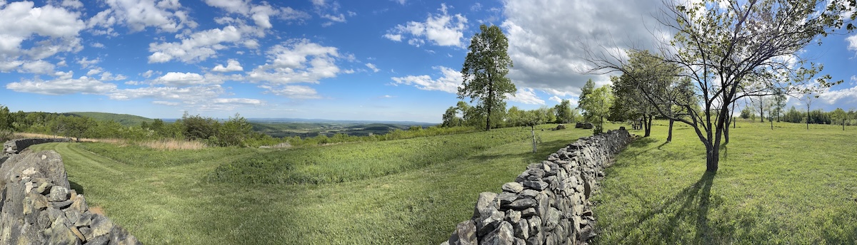
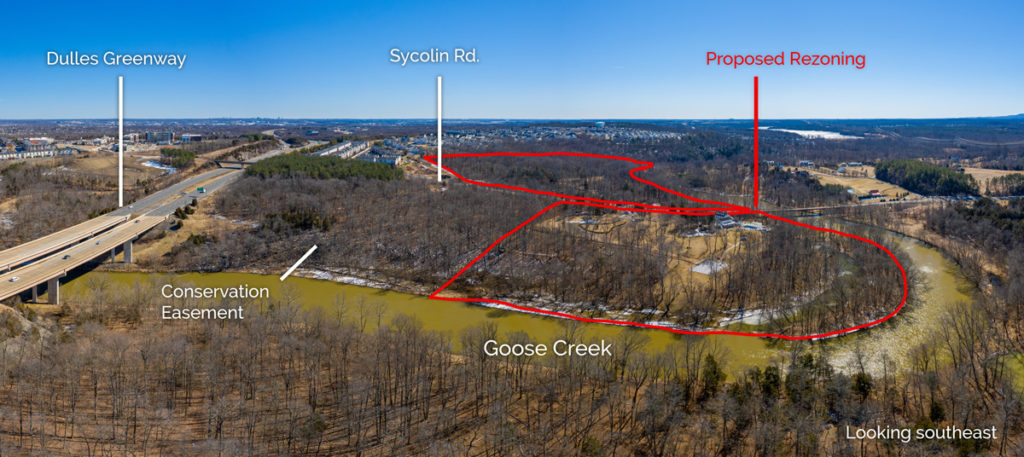
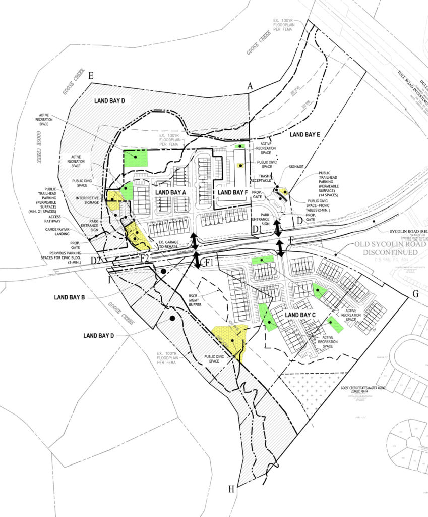
Goose Creek is a premier natural resource in eastern Loudoun, but it is under threat from development. The Goose Creek Overlook application, proposes to rezone a group of properties located just south of the Greenway, on the eastern slope of Goose Creek for intense residential development. These 46 acres currently include forest and steep slopes next to the creek. The site would be stripped and blasted in order to add 238 townhouses and multifamily units on the north and south sides of Sycolin Rd.
The properties are located just upstream from a public drinking water intake and are directly adjacent to county-owned land under conservation easement. The proposed development would also effectively double the impervious surface that would exist if single family houses were built under current zoning.
Our take? If approved, this rezoning would have an extremely negative impact on Goose Creek due to the properties’ location and numerous steep slopes.
Talking points:
- Affordable Housing – Loudoun needs a lot more affordable housing, but this is a highly sensitive location that isn’t suitable for increased development. There is also no access to public transportation and the location isn’t walkable to jobs or services people rely on, so every trip needs to be made by car. That makes it more expensive for residents who will live here. The county must take these important factors into account in order to create true, long-term affordable housing.
- Impervious Cover – Roofs, parking lots and sidewalks block rain water from soaking into the ground so it runs off them at high velocities and volumes, carrying with it oils, metals, fertilizers, pesticides, salts and trash generated by human activity. The proposed density would double the impervious surface, and the steep slopes further increase the negative impact.
- Trails and Parks – Loudoun needs more public trails and parks, but the county could make alternate plans to provide parking and build trails for this and other county-owned land under easement without approving this development.
- Drinking water -The properties are located just upstream from a public drinking water intake. The cleaner the stream, the easier and less expensive it is to provide clean drinking water, so it’s important to minimize all types of development in drinking water & reservoir watersheds. Runoff from impervious surfaces, soil compaction and the loss of natural vegetation from intense development can have a detrimental effect on stream health.
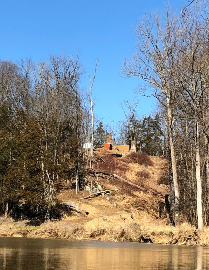
- Steep slopes – The steep slopes on this property make this a bad location for intense development. Major site disturbance will be needed. Creating huge potential for erosion. They will have to blast to put in both the housing and underground stormwater vaults, due to both the steep slopes and diabase rock underneath the site.
- Comprehensive Plan – the county’s Comprehensive Plan that was developed over three years with input from residents calls for this area to be less densely developed than the proposal calls for. When we rezone, it has to be good for the county and good for residents. This site is neither. Before approving any more rezonings in this area, the county should create the source water protection plan called for in the Comprehensive Plan, with special attention given to more protective requirements to reduce development on steep slopes, limit clearing and increase setbacks from Goose Creek.
- Climate change – We are entering a period where we know there are going to be more and more extreme weather patterns, including flooding. Yet, this proposal would remove natural cover and permeable ground on moderate and steep slopes right next to Goose Creek. If we also want to reduce people’s reliance on cars and fossil fuels, we need to be thoughtful about creating walkable, transit-oriented places to live.
More detail:
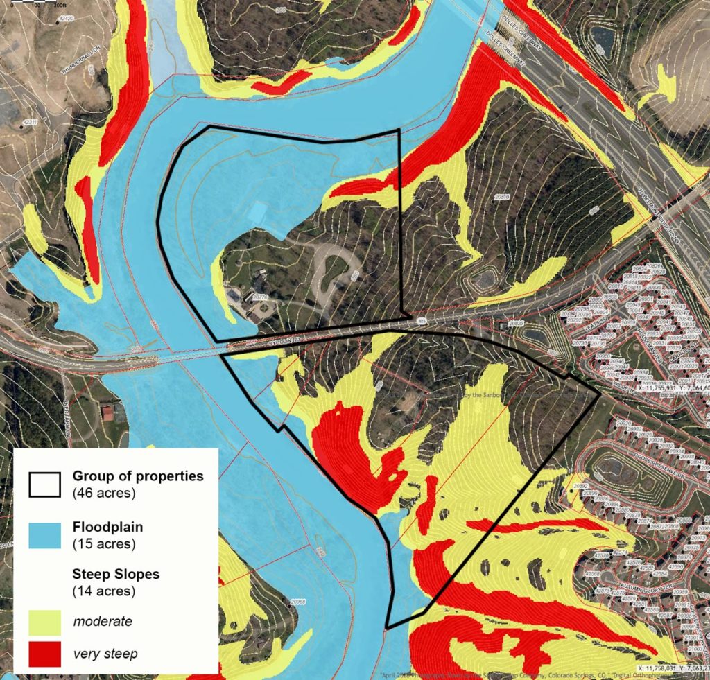
The developer is trying to increase the number of allowable units on a site where 29 of the 46 acres are constrained with either unbuildable floodplain (15 acres) or sensitive steep slopes (14 acres). It’s already a hard spot to develop, and that’s before trying to cram in more than currently allowed. Including additional residential development would mean there’s not enough space to meet the county’s civic space standards, and the developer is asking for parking reductions as well. While they are offering a trail along the creek and an affordable housing component, the county should be setting standards to get those features as a matter of course.
Given the nature of the site, we believe that the base zoning or something far less intensive to protect the natural resources is warranted. In fact, the Comprehensive Plan states this is a place where voluntary 1000-foot buffers for the scenic creek and reservoir should be considered. It also states that public or private preservation plans should be promoted on properties with particularly sensitive environmental, cultural, and historical characteristics (which these properties have). The streamside habitat of Goose Creek is unparalleled in suburban Loudoun, and preservation would offer a host of co-benefits for the health, safety and welfare of people and wildlife.
Suburban Loudouners deserve to have these protections and natural areas nearby. With few places like this left, the development is too intense for the location, and the trade-off isn’t worth the destruction.
The Board of Supervisors is scheduled to vote on Goose Creek Overlook on Tuesday, March 2. If you think that this development in that location is a bad idea, let the Board of Supervisors know what you think by sending an email to [email protected].

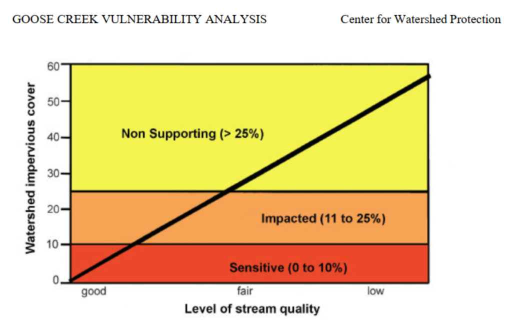
Too Much Impervious Cover
Impervious cover negatively affects stream quality. More impervious cover leads to lower stream health, which is less able to sustain life.
A detailed study* of the Goose Creek watershed determined the average impervious cover percentages for our zoning:
- 1 unit per acre = 14.3% imperviousness (about the density of current R-1 zoning)
- 4 units per acre = 27.8% imperviousness (close to what the proposed density would be)
While the impervious surface from 1 unit per acre will have an impact, the proposed density would double the impervious surface, and the steep slopes further increase the negative impact.
* Goose Creek Vulnerability Analysis, Center for Watershed Protection, 2002
Questions? Contact Gem Bingol at [email protected].