The following text was taken from an email alert sent out on April 16, 2021. Sign up for PEC email alerts >>
Dear Supporter,
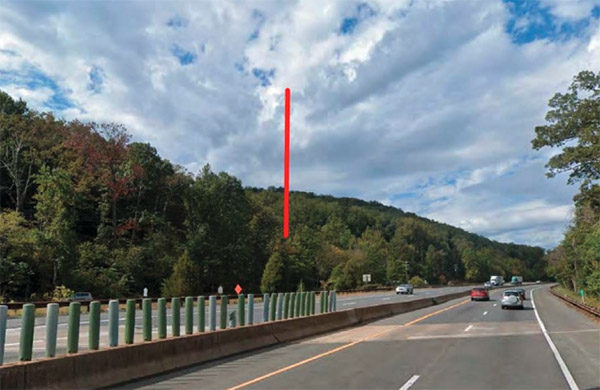
We have learned that Rangel Communication Inc. will be filing an application with Fauquier County for a 199-foot monopole tower and tower compound in Thoroughfare Gap, just east of the Broad Run Post Office along the south side of Rt. 55. This area, steeped in history, is the gateway into Fauquier County from Haymarket to the east.
To obtain approval for construction, the tower must go through a federal and local level review, which includes a balloon test to determine visual impact. The balloon test will be conducted on Tuesday, April 20 between 8 a.m. and 12 p.m., with an inclement weather date of April 21, 8 a.m. to 12 p.m.
The Process:
Under the National Historic Preservation Act (NHPA), the Federal Communication Commission evaluates the tower application through what is called a Section 106 review process. As a part of this process, the Virginia Department of Historic Resources, interested parties, and the public are able to weigh in before a final decision is made. The visual effect of this tower in particular is especially important because it is located in the Broad Run-Little Georgetown Rural Historic District, Thoroughfare Gap Battlefield, and the Buckland Mills Battlefield. It is also within 0.5 mile of the Chapman’s Mill / Beverly’s Mill and may have a visual impact on this beloved resource, which is listed in the National Register of Historic Places.
Once the Section 106 review process is completed, the Fauquier County Board of Supervisors will hold a public hearing to consider the applicants’ waiver application. (View pre-application materials here)
Our Take:
At this time, the applicant has not stated the purpose for this tower. However, given the location and proximity to Interstate 66, it appears the likely purpose is to improve cellular service on that roadway. We are unaware of any proposal to include broadband services at this point and, given the population density of the area, are skeptical the tower would include these services in the future.
Assuming cellular service along I-66 is the primary purpose, we believe there are numerous less impactful solutions that could be employed. These include alternative sites, shorter towers, different color schemes, stealth technologies, and collocation to name a few. All of these options could be designed to provide equal or greater coverage without such severe impact on numerous historic, scenic and cultural resources. Addressing visual impacts is not cost prohibitive and is standard practice, especially in highly sensitive landscapes.
PEC has long fought to protect the viewshed, history, and natural resources of Thoroughfare Gap and the Bull Run Mountains. We are very concerned about a tower at this location and the impact it would have on the atmosphere of the area and the gateway into Fauquier County.
I will be monitoring the balloon test on April 20 (or the April 21 rain date) and hope you are able to take a look if you’re in the area. As always, please feel free to reach out to me with questions.
Sincerely,

Julie Bolthouse
Fauquier Field Representative
The Piedmont Environmental Council
[email protected]