The Outer Beltway, and its component parts the Bi-County Parkway and 6-laned Northstar Blvd, is a bad deal for the residents of Prince William and Loudoun County. It’s also a bad deal for people who live in counties and cities to the east and west, as well as Virginia taxpayers as a whole.
Presentation from a community meeting in Ashburn on 3/18/13:
Rather than solve traffic problems, a billion dollar Outer Beltway will spark higher levels of residential development within the Prince William Rural Crescent and the Loudoun rural Transition Area, adding more traffic to already congested east-west commuter routes. It will bring noise and pollution, split properties and neighborhoods, and reduce community access to local roads and services.
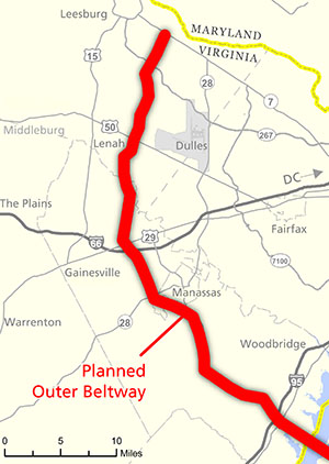
The biggest peak hour commuter transportation problem we have in Northern Virginia is with east-west travel on routes like I-66 and Route 50. Where there is a need for high volumes of traffic to move north-south, it’s on Route 28, from I-66 to jobs in the Dulles Corridor east of the airport. Scarce transportation funds must be used in smart ways to fix I-66, Route 50, and Route 28 — like improving the I-66/Route 28 interchange near Centreville and adding VRE service to Gainesville.
The Impact on the Park
In order to gain approval for the Bi-County Parkway portion of the Outer Beltway, VDOT must first secure an agreement from the National Park Service. This is due to the fact that the highway would cut through the western edge of Manassas National Battlefield Park at Brawner’s Farm and along Pageland Lane. This has proved to be an important sticking point — because the National Park Service is under an obligation to protect this important historic resource, but it is also under an obligation to comply with 1988 federal legislation which directs it to “develop plans for the closing of those public highways (known as routes 29 and 234) that transect the park”.
It is within this context that Secretary of Transportation Connaughton and the Virginia Department of Transportation are placing the National Park Service into a negotiating box that could result in the worst of all worlds for the Battlefield and the community. They are boxing in the National Park Service to accept a major highway that could spur development near the park in exchange for control over just one of the roads, Route 234, and without adequate commitments to reduce traffic on Route 29 through the Battlefield.
When all is said and done, the Battlefield could end up with both a major highway slicing through the historic landscape of the Second Battle of Manassas AND an increase in traffic on Route 29.
The Impact Locally and on the Region
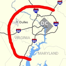
 |
| Full version of this map. |
VDOT is not proposing a local road improvement that would meet the needs of local traffic, but the most significant segment of a billion dollar 45-mile Outer Beltway. At the same time, VDOT is also studying a bridge crossing to Maryland, as part of an effort to promote an expansion of cargo shipment and distribution centers at Dulles Airport. The ultimate effect of both efforts will be to attract freight truck traffic, through travelers, and encourage more development in western Prince William and areas west of Dulles and Arcola in Loudoun. The thousands of additional vehicles, including construction trucks, large trailers, and delivery trucks as well as new cars on the road will bring not only congestion but also associated noise and air pollution.
Locally, the proposed highway would reduce, not enhance access for residents in Prince William’s Rural Crescent, favoring long-distance travelers over local resident’s access to daily needs. This will be particularly true if it’s built as a full or partial toll-road as VDOT is proposing. For residents along the existing Route 234 in southern Prince William it would convert a local road to an interstate truckway, while closing off numerous existing access points. For both Prince William and Loudoun residents, the highway would divert scarce revenues from fixing east-west commuter problems. When these problems are combined with the additional residential development that the highway would bring, the community will forever lose the quality of life that residents value so much.
In addition, the multiple crossings of streams within the Bull Run watershed, which is an important public water supply and habitat for wildlife, combined with accelerated land development, threatens both water quantity and water quality. The potential for increased stormwater from both the highway and the additional development and the possibility for hazardous materials spills from increased truck traffic are in conflict with the federal, state and local policies to reduce current pollution loads and stormwater velocity into Bull Run.
Governor McDonnell and Secretary Connaughton’s highway just doesn’t add up:
- It doesn’t address the overwhelming east-west traffic need.
- It would open up the Rural Crescent in Prince William and the Transition Area in Loudoun, more than 100,000 acres, to accelerated development and additional traffic.
- The Outer Beltway would cost at least $1 billion according to VDOT, and the associated connector roads to the west side of Dulles could cost another $500 million or more.
- Rather than help current residents, it will reduce their access to local roads and services.
- The public rationale is based on speculative, and not independently verified, claims by Dulles Airport of their need to expand cargo shipping.
- Yet cargo shipped at Dulles today is just .1 percent by volume and .2 percent of the value of all freight shipping in Northern Virginia.
- Dulles cargo shipments declined 11.5 percent from 2011 to 2012. Most cargo being shipped by air is lighter weight and high value — particularly mail and packages tied to our international and defense firms and federal government — most of which is probably going to and from destinations east of the airport.
- The claim that the Port of Norfolk and Dulles Airport need to be connected is particularly questionable given that the port handles heavy cargo and not the sort of goods that need rapid shipment.
- Finally, why does Dulles need to capture market share from other airports more suited to cargo shipping anyway? Dulles’s greatest value is in moving people who reach their flights by the terminal on the east side of the airport.
Alternatives that would Better Address the Needs of Commuters, the Community and the Battlefield
We have crafted an alternative to VDOT’s highway and welcome your feedback.
Our proposal focuses on fixing east-west routes for commuters, it provides lower impact local road fixes and connections to help local residents, it preserves the Rural Crescent and Transition Area, and could allow for the roads to be closed through the Battlefield (although it’s not clear that would ultimately be necessary, due to the reduced traffic that would result from implementing the alternatives we’ve suggested). It would meet the goals of the 1988 legislation while rejecting VDOT’s proposed highway. It would improve access to Dulles with the completion of upgrades to Route 28 from I-66 north, improvements to the I-66 corridor, and upgrades to the Route 234/Route 28 connection and Route 28 on the east side of the Cities of Manassas and Manassas Park. The composite set of connections is designed to improve traffic movement throughout the area, benefitting more travelers and trip types than would the single large north-south highway proposal.
Any limits on Routes 29 and Route 234 within the boundaries of Manassas National Battlefield Park should be matched or preceded by long promised and much needed transportation improvements, including some mixture of the following:
Potential East-West Improvements:
- Co-location of Route 29 onto Interstate 66
- Focus on I-66 corridor upgrades including extension of VRE to Gainesville and Haymarket, Metrorail to Centreville, and express bus/HOV-3 between Fauquier and Arlington
- Complete the I-66 Gainesville Interchange
- Upgrade the existing east-west road at the southern boundary of the Battlefield between the Park Headquarters and Groveton Road if necessary for local movement
- For the Route 50 corridor — install dedicated bus lane and complete proposed parallel roads (maintain the undivided two lane rural arterial west of the proposed Lenah Loop Road)
- Improve the interchange of Braddock Road and Route 28
- Use the Route 50 northern parallel connector as a truck connector from Route 28 to Route 606, providing access to future Dulles Airport facilities
- Utilize the east-west local connector known as Cedar Ridge Boulevard to connect to an upgraded Bull Run Post Office Road
- Complete the Route 50 southern parallel connector
Potential North-South Improvements:
- Finish construction of the Route 28 interchanges between I-66 and Route 7 and improve the connection from I-66 east to Route 28 north. This would improve access from the I-66 corridor to the major job concentrations east of Dulles Airport
- Provide a bus rapid transit or light rail connection from the Cities of Manassas and Manassas Park up to the Dulles Corridor along Route 28
- Recognize the existing upgrade of Route 15 in Prince William and install roundabouts at Route 15 and Route 234 (Sudley Road)
- Utilize roundabouts to ease the flow of N-S traffic in the Gum Springs/Pageland Road N-S corridors, with roundabouts located at Route 659 (Gum Springs Road) and Route 234 (Sudley Road); at Sudley Road and Pageland Lane; and at Pageland Lane and Route 29.
- Make targeted upgrades for safety and install roundabouts where necessary for Catharpin Road, Bull Run Post Office Road and Pleasant Valley Road. Roundabout locations include Catharpin and Sudley Rd; Bull Run Post Office Road and Route 29; Bull Run Post Office Road and Braddock Road; Pleasant Valley Road and Braddock Road.
- In Loudoun, between Braddock Road and Route 50, implement N-S connections for local traffic; and between Route 50 and Route 7, complete upgrade of Route 606 and Route 659 to four-lane divided roadways.
- In Loudoun, install a roundabout at Evergreen Mill Rd and Belmont Ridge Rd In Loudoun, increase transportation funding so that bottlenecks and missing links identified in the County’s Eastern Loudoun Transportation Study Segment Analysis that are currently in Phase 2 and Phase 3 (in Dulles South) can be completed sooner rather than later.
Improving Area Traffic Flow South of I-66
- Evaluate additional road connection improvements south of I-66 including Wellington Road, Balls Ford Road, Sudley Manor Drive and Godwin Drive (Godwin would also meet north-south movement needs and was part of one of the TCP alternatives — use Mr. Robert Moler’s connection recommendation for connecting to Route 28 and I-66)
- Install Route 234 to Route 28 interconnection improvements and Route 28 upgrades on the east side of the Cities of Manassas and Manassas Park up to I-66
Growth Projections, Land Use and other Factors
Recognize and address the significantly greater east-west travel demand as compared to north-south movement in the area west of Route 28 in the I-66 and Route 50 corridors Incorporate the more likely scenario that the vast majority of job attractors will remain east of Route 28