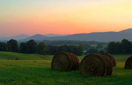
Virginia’s Piedmont is a unique place with exceptional natural resources, productive farms and forests, and a landscape steeped in history. The farms and forests in Culpeper Soil and Water Conservation District’s five-county region are vital to the financial well-being of the regional and state economy, and each year hundreds of thousands of tourists come to experience our natural wonders and historic heritage. This article was written for the Culpeper Soil and Water Conservation District’s Spring 2013 newsletter.
Our Region
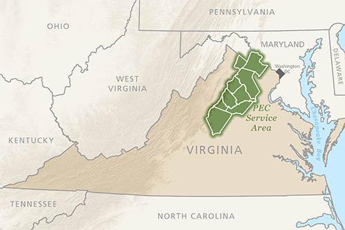 PEC focuses on nine counties and one city in the northern Piedmont of Virginia: Albemarle, Charlottesville, Clarke, Culpeper, Fauquier, Greene, Loudoun, Madison, Orange, and Rappahannock.
We also team with local organizations to promote thriving communities and healthy natural resources in a much larger region, including the Shenandoah Valley, the central Piedmont, and the Journey Through Hallowed Ground Corridor. In addition, we are proud to serve as fiscal sponsor of the Coalition for Smarter Growth, an organization that focuses on land use and policy in the greater Washington D.C. area.
Transcript of WINA interview with former CTB member Jim Rich
Charlottesville Right Now, Thursday, May 30, 2013
Jim Rich, a former member of the Commonwealth Transportation Board, shares his thoughts on the Western Bypass.
CATCO Green Book
The Charlottesville-Albemarle Transportation Coalition (CATCO) is a citizen group formed in 1988 to respond to proposed improvements to the local Rt 29 corridor. Their objective was the development of real solutions to emerging congestion problems. Their work included opposition to the Western Bypass, specifically after it was elevated as a priority ahead of previously agreed upon, more effective solutions. The CATCO Green Book summarizes these efforts through 2000. It provides an invaluable digest and summary of the genesis of the Western Bypass and why this community has long opposed it.
Sprawling Development Proposed on Outskirts of Opal
Most everyone who travels south of Warrenton on Rt. 29 ends up stopping (at least momentarily) in Opal. On weekday mornings and weekend afternoons traffic gets backed up in both directions, with drivers struggling to turn on to Rt. 17 or get in and out of existing businesses.
This Thursday, the Fauquier County Planning Commission will consider a development proposal that would make the traffic situation worse. The proposal would open up more than 80 acres of agricultural land to strip-commercial development — putting a burden on County services like water, and ultimately detracting from future economic opportunities in the area. This text is from an email alert sent out on May 27th, 2013.
School Location Matters
Building a new school, like any major construction project, requires a lot of thought and planning. And with that planning comes the need to address the concerns citizens in the nearby area might have about its impacts — traffic, noise and lights, just to name a few. Which is why it's concerning to hear that Loudoun County is considering changes to the Zoning Ordinance that would allow public schools to be built 'By-Right', pretty much anywhere — removing the public's ability to give input. This text was taken from an email alert sent out on May 21st, 2013:
Fuzzy Math, Shoddy Design
The saga continues. In order to keep the Rt. 29 Western Bypass proposal within their budget, VDOT accepted a “modified design” to the southern terminus last year that is significantly different than the one presented in VDOT’s Environmental Assessment. And it is now becoming clear that there are some major flaws in this cheap design — flaws related to traffic flow and safety, and that actually increase the travel time on the Bypass. This text is from an email alert we sent out on May 14th.
We Drink This Stuff
Loudoun, like all counties in our area, is considering ways to reduce the pollutants flowing into local streams and creeks, including sediment, nitrogen, phosphorus, among others.
Orange County Planning Commission Hearing Summary, May 2nd
Last night, the Orange County Planning Commission voted unanimously to table the Comprehensive Plan in order to address some of the comments they had received from the public. Over thirty people spoke with the vast majority calling for a plan that recognized the agricultural nature and beauty of the County. Concerns raised included, the lack of public input, methodology used to create the future land use map, designation of Route 20 and 15 as Potential Economic Development, an agricultural designation (A-2) geared for residential development, and a vision statement that allows for development to trump agriculture.
Hearing this Thursday: Orange Unveils Sprawling Vision
As I mentioned last month, the Planning Commission has released a draft plan for the future of Orange County that takes a startling turn from the plan previously approved by residents of Orange. It includes a map that lays out what the county would look like in 2035 — including major development along Route 20 and increased residential and commercial development on agriculturally zoned land, among other things.
Making matters worse, they scheduled the public information session (where people are supposed to learn about the proposal) on the same night as the public hearing (where people are supposed to weigh in on the proposal). This text was taken from an email alert we sent out on April 30th, 2013.

Remembering Celia: Honoring one of Madison County’s 2012 easement donors
Celia Porter Dollarhide (January 1940 — December 2012) and her siblings never quite had a hometown. Their father, Robert Porter, Jr., was a general in the U.S. army and the family moved often. So, when General Porter retired in the ‘60s and settled at Middle River Farm in Madison County — the 140 acre tree farm became the family’s home base.