Albemarle County is undergoing an update of its Comprehensive Plan, called AC44 — to serve as a guideline for development and infrastructure in the County over the next 20 years. Given that the maps that depict the wide range of Rural Area resource values are scattered within various County plans and on the County’s GIS platform, PEC has created an interactive map that combines several layers of mapped resources into one. Our interactive map can support community engagement as the County moves through the AC44 Comprehensive Plan update process focusing on major policy goals and objectives.
PEC’s interactive Rural Area map can also support the review of proposed projects within the Rural Area such as utility-scale solar facilities, new electric transmission lines, rural subdivisions, and non-residential land development proposals. PEC has been advocating for strong protections for the values in the Rural Area and smart policies in the Development Area to support this. See our policy recommendations and platform for more information>>
Viewers can use the online “Layer List” found on the right-hand side of the map to see the key and toggle on and off layers of interest.
View our Rural Area map fullscreen>>
PEC developed the interactive Rural Area map to:
- Provide a spatial representation of the valuable/sensitive/significant characteristics within the Rural Area on a single mapping platform;
- Support advocating for policies to protect the Rural Area from sprawl and incompatible development; and
- Support PEC’s high-level recommendation that the County should include a detailed recommendation for the preparation of a Rural Area Plan in the comp plan update.
You can download three PDF maps that include combinations of the map layers listed above:
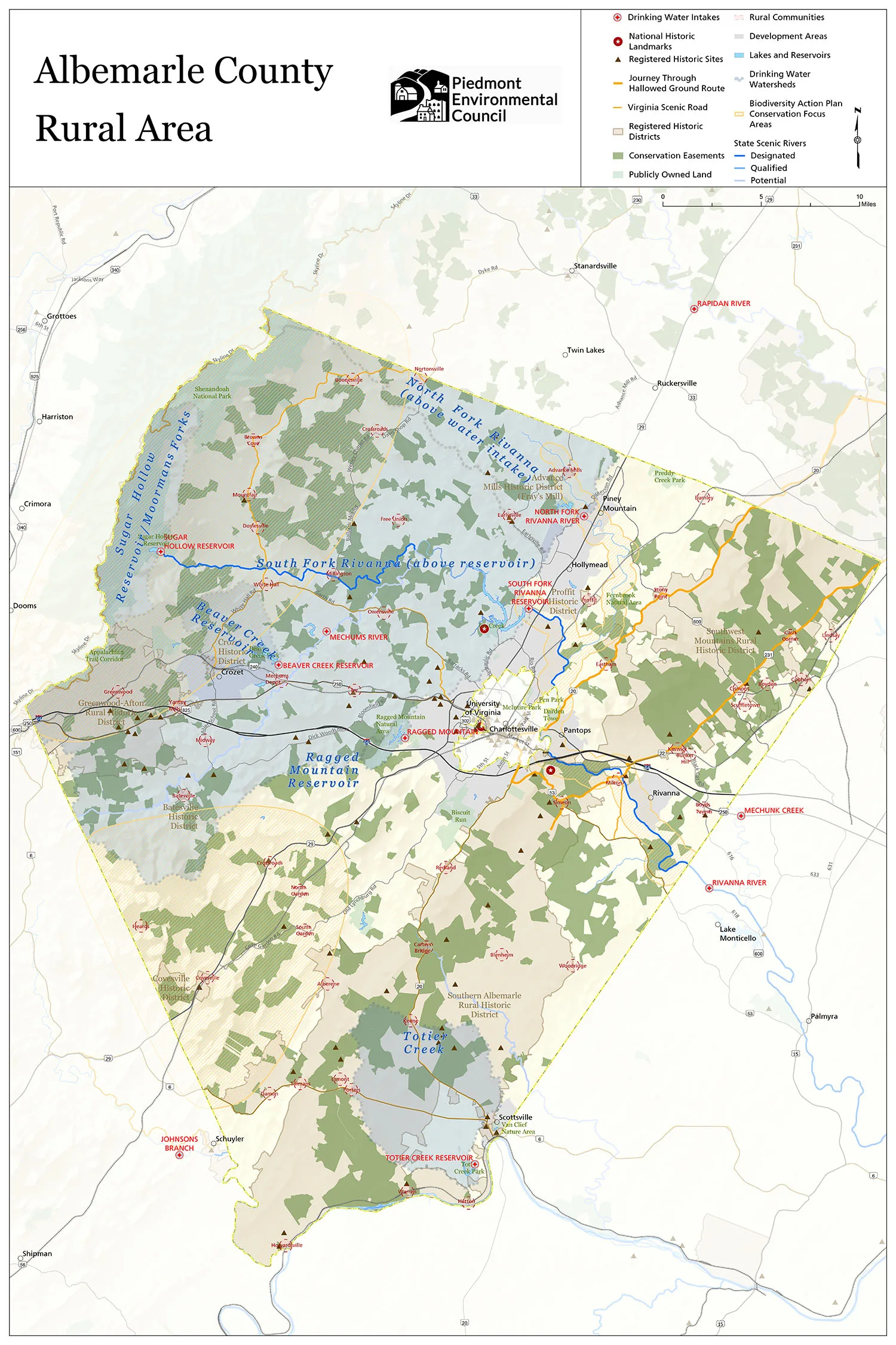
- Albemarle County Rural Area (all layers)
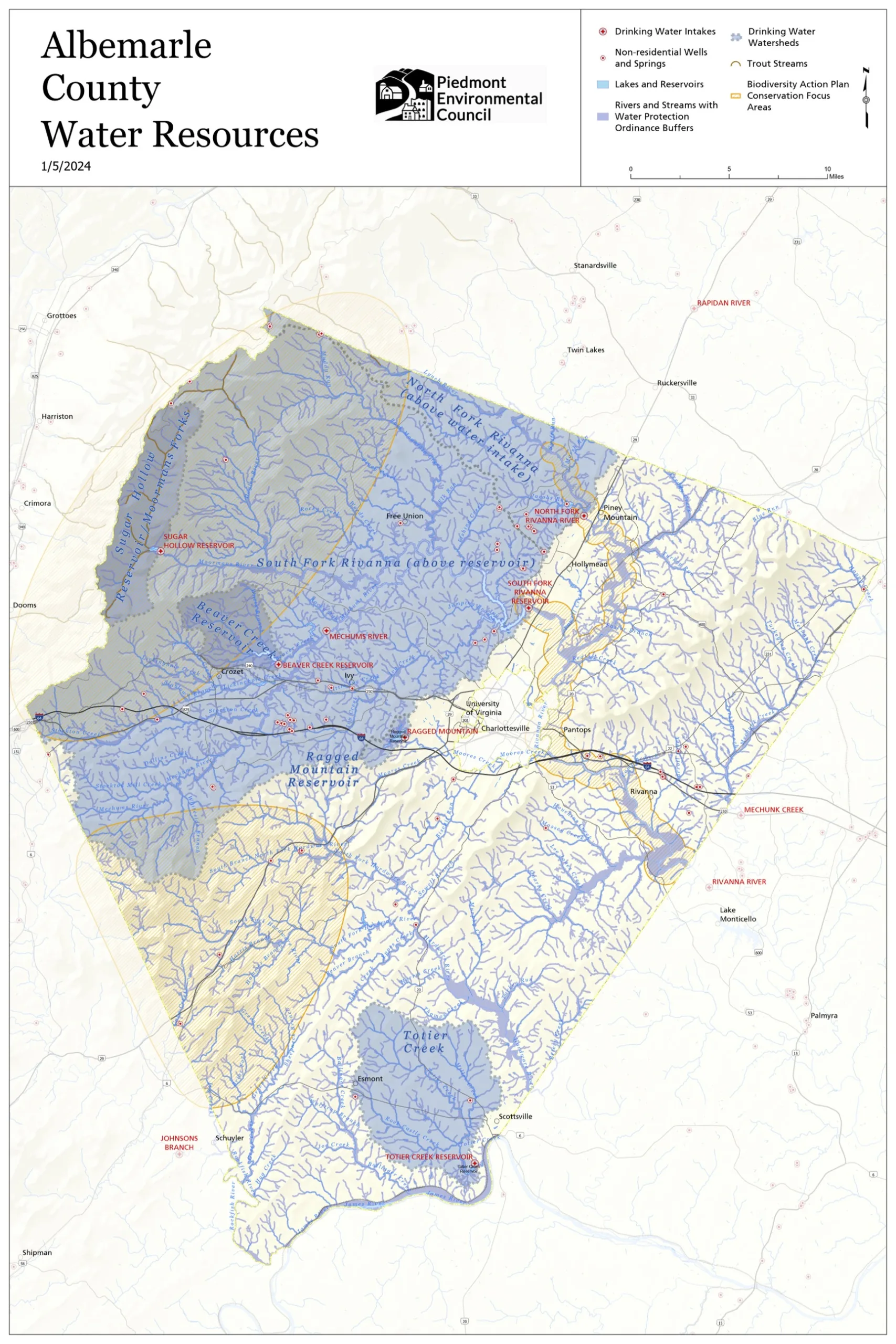
- Albemarle County Water Resources
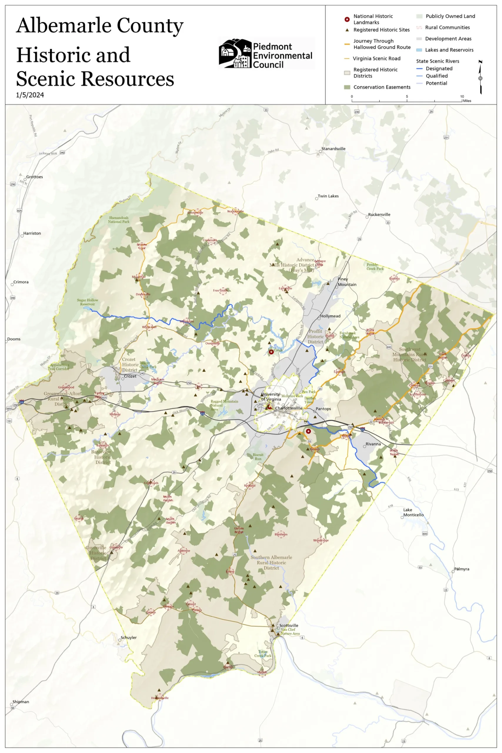
- Albemarle County Historic and Scenic Resources
The interactive map above was created, in part, to contrast the map below — the Generalized Land Use Plan prepared by Albemarle County which is the first map in the County’s 2015 Comprehensive Plan. The Development Areas represent 5% of the County, or 37 square miles, and are identified by the various colors indicating designated areas for housing, commercial development, light-industrial uses, open spaces, and other uses. The Rural Area is approximately 95% of the county, or 689 square miles — it is rendered in white here, making it appear empty.

However, we know from the 2015 Comp Plan policy goals, objectives, and strategies for the Rural Area, Natural Resources, Historic, Cultural, and Scenic Resources, and Economic Development that Albemarle County values its natural resources and magnificent cultural landscapes.
The County’s Rural Area is home to forests and farmland, wildlife habitats and corridors, waterways, orchards, vineyards, and historically and culturally significant properties. These rural lands sustain agricultural and forestry operations that are both economically and ecologically important to local communities and to the region. County residents and visitors prize these special places and important resources alike. Albemarle has substantial areas of conservation and has been a model for sustained local efforts to connect and protect critical resources. These conserved lands also help to maintain the rural character and scenic beauty of the Rural Area, and perhaps most importantly, provide increased resiliency by offsetting some of the most harmful climate impacts. It would be costly and difficult, if not impossible, to restore these important places and resources if we lose them.
Additional Background:
Community Surveys in Albemarle County: Perspectives on Planning, Preservation, and Natural Resources from 1994 to 2023
To better understand how residents value the Rural Area, PEC undertook a review of community surveys conducted in Albemarle County from 1994 to the present focusing on survey responses related to the environment, growth management, natural resources, preservation, and rural areas. The surveys reviewed in our Community Surveys in Albemarle County: Perspectives on Planning, Preservation, and Natural Resources from 1994 to 2023 have historically played a crucial role in shaping strategic plans and comprehensive plans in Albemarle County. The results of our findings identify a longstanding and consistently high commitment to growth management policy, preservation of natural resources, and protection of rural area character.
The results of our analysis underscore the priority Albemarle County residents have overwhelmingly given to policies tied to the environment, preservation, and smart growth for nearly 30 years. In this time, Albemarle County residents have given high value to policies pertaining to the environment and preservation, access to nature and recreation, reinforcing the pivotal role these themes play in the community’s ethos and direction.
“Albemarle County’s Development Areas will be attractive, vibrant, areas for residents and businesses, supported by services, facilities, and infrastructure. Growth will be directed to the Development Areas and the County’s Rural Area, with its agricultural, forestal, historic, cultural, scenic, and natural resources, will be preserved for future generations.”
The County’s 2015 Growth Management Policy
PEC research on the Albemarle County Rural Area Performance Value
The facts gathered were intended to promote a better understanding of Albemarle’s Rural Area with a focus on agriculture, working forests, and ecosystem services. The research reveals a more complete understanding of Albemarle’s Rural Area, why agricultural statistics should be more carefully studied, and expand upon the other values being provided through Rural Area land use and associated industries.
Our research was informed by both publicly available and exchanged information, through ongoing communications with the Virginia Department of Agriculture and Consumer Services, the Virginia Cooperative Extension, USDA 2017 Census of Agriculture (at the time of writing, we relied on the latest USDA Census of Agriculture), local, state, and national grower’s associations including the Virginia Wine Association, USAPPLE Association, Virginia State Horticultural Society, the USDA National Agricultural Statistics Service (NASS), Weldon Cooper Center For Public Service, Virginia Department of Forestry, The Central Virginia Partnership for Economic Development and The Virginia Tourism Corporation. Ecological benefits of land cover and land use data are provided through Chesapeake Tree Canopy Network in cooperation with USGS, Chesapeake Conservancy, the University of Vermont Spatial Analysis Lab, the Chesapeake Bay Program, and information collected from Albemarle County’s websites.
This is what we learned about the County’s Rural Area…
- Ranked 25th in the Commonwealth for crop production, out of 97 reporting localities.
- Second highest producing county in Virginia in the fruits/tree nuts/berries category.
- Third highest producing county in Virginia in the horses/ponies/mules/burros/donkeys category.
- Produces 21 percent of all grapes harvested for wine production in the Commonwealth.
- Produces nearly half of all grapes harvested for wine production in the Central Virginia region.
- Ranks above the 70 percentile in total cattle count in the Commonwealth for years 2022 and 2023.
- Ranks 39th out of 110 Virginia localities in the total tax value generated across all timber types, ranked notably high among hardwood timber types.
- Contributes nearly 12 percent of statewide land devoted to orchards, and to the present remains a key region for fruit trees, in particular apples – a nationally competitive and historically significant contribution to production and the continuity of use.
- Leads all Central Virginia counties in the number of people employed in agriculture, forestry, fishing, and hunting combined. The number of people employed in these industries has also increased over a five year period.
- $76.3 million annual benefits provided by tree cover (in reduced air pollution, stormwater management, and sequestered carbon dioxide).
- Total annual air pollution removal value of 20,720 lbs removed annually; $3.0 Million saved annually.
- Gallons of reduced stormwater runoff value of 287.9 million gallons annually; $2.6 million saved annually.
- The County’s forests and tree cover sequester nearly a million metric tons of carbon annually.
Special thanks:
This WebMap was created by PEC’s GIS Specialist Watsun Randolph with support from PEC’s Rob McGinnis, Kim Biasiolli, and Faith Schweikert. Questions? Contact Rob at [email protected].