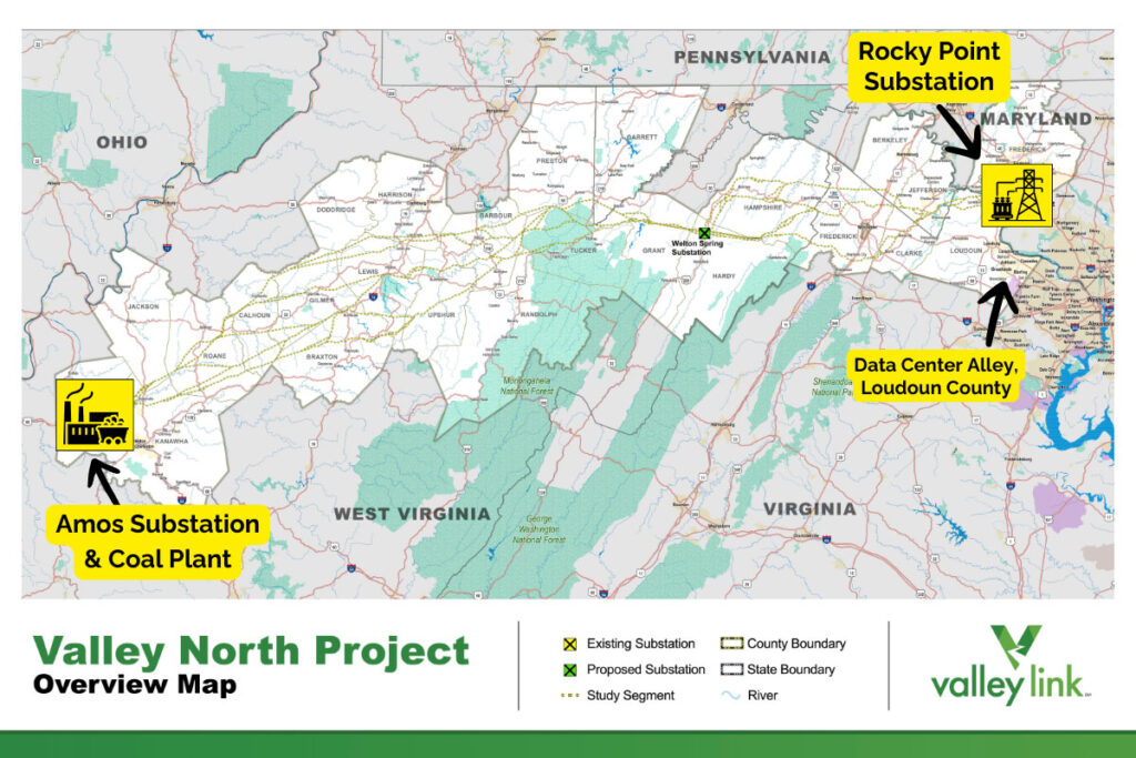
Several routes are being considered for a massive 260-mile high voltage transmission line through West Virginia, the northern portion of the Shenandoah Valley and Maryland
I am reaching out to you today with an urgent alert on a major transmission line project proposal that has the potential to have significant impacts in Clarke County and the surrounding area, and to share details of an open house on Tuesday, July 7 where you can learn more and voice your concerns.
On an unrelated note, Clarke County staff have finished a draft of the County’s new Rural Lands Plan, which is set to be discussed at a public hearing on Friday, July 10. Learn more on our website →
Valley Link Proposes New Transmission Line Project
Last week, Valley Link Transmission – a joint venture between Dominion Energy and two other utilities – sent out notices to West Virginia, Virginia, and Maryland residents revealing preliminary study routes for Amos-Rocky Point aka “Valley North.”
This project would consist of 260 miles of new 765-kilovolt (kV) transmission lines connecting the John Amos coal plant in Putnam County, West Virginia (the location of a well-known coal-fired power plant), and the Rocky Point substation in Frederick County, Maryland.
If constructed, this project would clear thousands of acres and impact hundreds if not thousands of property owners in the region.
Valley Link has proposed two projects in tandem, which together represent two of the highest-voltage transmission line projects ever proposed in Dominion Energy’s territory:
- a southern portion called Joshua Falls-Yeat, which could carve through as many as nine Virginia counties. Read our latest email about this project →
- and now, a northern portion, known as Amos-Rocky Point or “Valley North”, which could cut through up to three Virginia counties and many more counties in Maryland and West Virginia.
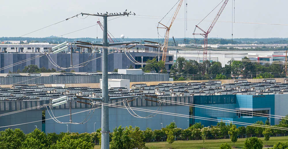
The northern portion would connect the second largest coal facility on the east coast (John E. Amos) to Rocky Point substation in Maryland, which ties directly into new 500kV lines being planned to deliver power for data center development in eastern Loudoun County. The structure design has not yet been determined, but Valley Link’s website proposes several study options for transmission line towers ranging from 150’ to 175’ tall.
Why Are These Transmission Lines Being Proposed?
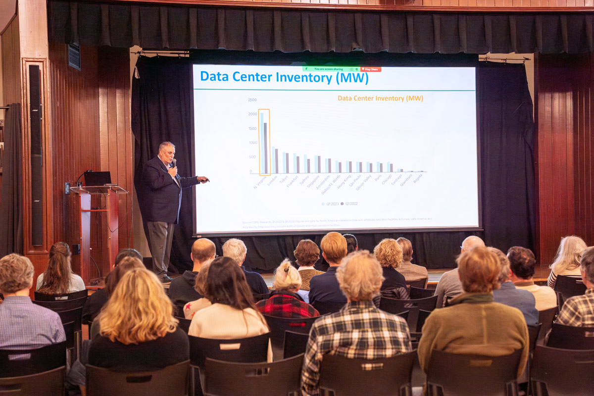
Both of these lines are being proposed to deliver power to Dominion Energy’s growing queue of data centers, a backlog that has now reached 70 gigawatts (GW) – which would quadruple the grid’s current peak demand.
Despite Dominion’s claims that the line is needed for regional stability, it is clear that without data centers, this line would not be needed and that there is no immediate benefit to the residents of Clarke County.
Why now? The electric grid operator for the mid-atlantic region, PJM, identifies areas where existing transmission lines might be inadequate or overloaded in the future based on where electric generation and demand are changing. The unconstrained growth of data centers has altered demand substantially in Virginia, and each new data center approved by localities adds more energy demand to the queue.
The maximum power demand ever recorded on the electric grid in Dominion Energy’s territory is about 24 GW. When PJM selected both the Joshua Falls-Yeat and the Amos-Rocky Point (Valley North) lines in February 2025 as part of its Regional Transmission Expansion Plan (RTEP), they were expecting that to grow to around 33 GW by 2030, an increase of about 40% in five years. In the year since, data center requests for power have only grown. Dominion recently told the SCC they’ve received requests to serve over 70 GW of demand, almost three times the current peak load, and are receiving an additional 2-3 GW worth every month from this singular industry.
This demand growth, which has occurred almost entirely since the data center rush kicked off in 2022, flows directly into new transmission line project approvals across the region.
PJM’s 2021 Transmission Expansion Plan called for $920 million in baseline transmission projects, which are upgrades or new builds of high voltage lines deemed regionally important. The 2025 RTEP recommended almost $12 billion, an increase of nearly 1,300% in just four years. Both the Amos-Rocky Point (Valley North) and Joshua Falls-Yeat lines are just two pieces of this uncontrolled buildout.
Route Options Vary Widely
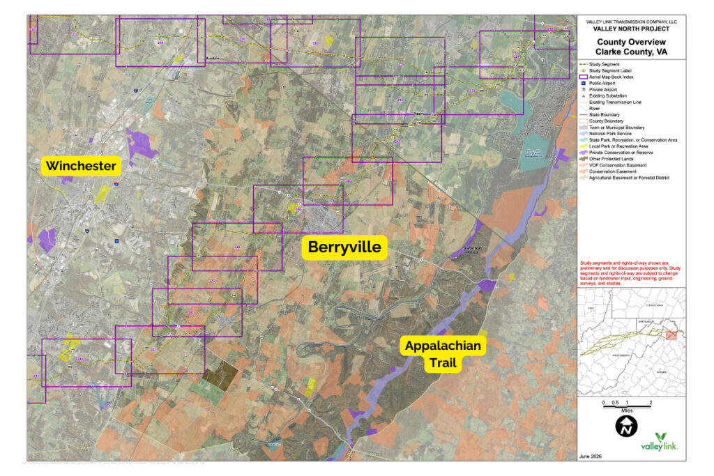
PEC staff spoke directly with representatives from Dominion regarding the two vastly differing potential route options currently under study for the Valley North project in Clarke County:
- A route to the north that would border the county and stay largely within existing rights of way.
OR - A route that would cut in from Frederick mid-county and involve significant greenfield line construction.
Dominion told us that the determining factor for which route it selects will likely be the routes in Frederick County. Depending on whether those lines are routed north or south of Winchester will determine the direction of the line in Clarke.
As Valley Link has frequently noted, high-voltage lines are like new electric superhighways. The land within several miles on either side will be subject to new development pressure – for new substations, power generation and data center proposals, similar to the development pressures opened up by interchanges on a highway. Because designs are subject to change, properties not affected by the current proposed routes could end up being impacted if the line shifts.
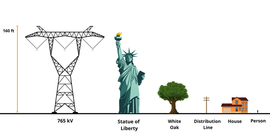
A 765 kV line is the highest-voltage transmission line we have in the United States. They can move up to 3500 MW of power over long distances efficiently; about three times as much power over the same distance as the next-largest size, 500 kV. For context, 500 kV lines are currently the highest voltage Dominion Energy operates in Virginia. The tradeoff to moving all that power is size.
Valley Link expects a typical transmission tower to be 160 feet tall, about the height of a 12-14 story building. Hundreds of these towers, dotted every quarter-mile, for 260 miles would be required. The corridor requires a cleared right-of-way of 200 feet, impacting significant swaths of open space and active farmland where the towers would be visible for miles in the distance.
With more than 26% of Clarke County’s total lands under conservation easements and significant efforts by the county and residents over many decades to preserve this rural community, it is important that Dominion consider route placement in Clarke that will minimize the impacts to the county’s lands and residents. This should be based on the impact to Clarke and not just as a by-product of route placement in other counties.
Learn More and Weigh In
We encourage you to attend the open house and let Dominion know you’re paying attention! We urge you and your neighbors (share this email with them) to attend so that you can learn firsthand about the project, ask questions, and raise concerns.
- Attend the Upcoming Valley North Open House in Clarke County: July 7, 2026 | 4 – 7:30 p.m. at the Clarke County Fairgrounds Ruritan Building • 890 W Main Street, Berryville, VA. Learn more and view maps of the potential routes on the Valley Link North Project website.
- Leave a comment with GeoVoice: The Valley North project map features a commenting system, GeoVoice, that lets you submit concerns with the project routes directly to Valley Link.
– Sign up for a GeoVoice account
– Navigate the map
– Use the green “+” comment box in the bottom right-hand corner to comment
– If you’re having difficulty submitting a comment on the map, please reach out to PEC’s Senior Energy Infrastructure Analyst, Michael Barber, at [email protected] - Stay Engaged as Routes Develop: Route selection will be based on community input from residents like you, as well as surveys and studies of environmental, cultural and historic resources, including the presence of conservation easements. Valley Link plans to hold a second round of open houses in late 2026 to further refine the project routes.
Project Timeline
- Community Meetings: June/July 2026
- Follow-up Community Meetings: late 2026 Valley Link will likely hold follow-up meetings later this year to discuss any route adjustments made in response to feedback received from the public — a reason to attend the community meetings! Meeting dates are to be determined.
- Filing with the SCC: 2027 Valley Link plans to file an application with the Virginia SCC to obtain a certificate of public convenience and necessity (CPCN) for the project sometime in 2027, following their public engagement timeline. Under state law, a transmission line of this size cannot be constructed without this certificate. There will be an opportunity for public comments during this process, so you can expect to hear from PEC in advance.
We will try to keep you updated as we learn more about this project and ways you can weigh in. Don’t hesitate to reach out if you have any questions.
Tia Earman
Senior Land Use Field Representative
Clarke & Loudoun counties
[email protected]