Speakers will Share an Embargoed Announcement
May 13, 2026
WHO: Members of the news media are invited to attend a press conference featuring speakers from The Piedmont Environmental Council, American Battlefield Trust, Central Virginia Battlefields Trust, Central Virginia Land Conservancy, Fluvanna Historical Society, Friends of Buckingham, Friends of Wilderness Battlefield, Historic Germanna, Preservation Piedmont and Scenic Virginia. Representatives from the Boards of Supervisors from nine counties are also invited.
WHAT: The press conference will reveal an important announcement that will highlight the concerning impacts of Valley Link’s proposed Joshua Falls-Yeat 765 kilovolt transmission line project, which would traverse nine Virginia counties.
Valley Link Transmission, a joint venture of Dominion Energy, Transource, and FirstEnergy Transmission, is proposing the largest transmission line ever seen in Dominion territory, stretch across mostly greenfield sites (previously undeveloped land) rich with abundant historical and cultural resources, natural and sensitive environmental resources, and tremendous scenic viewsheds.
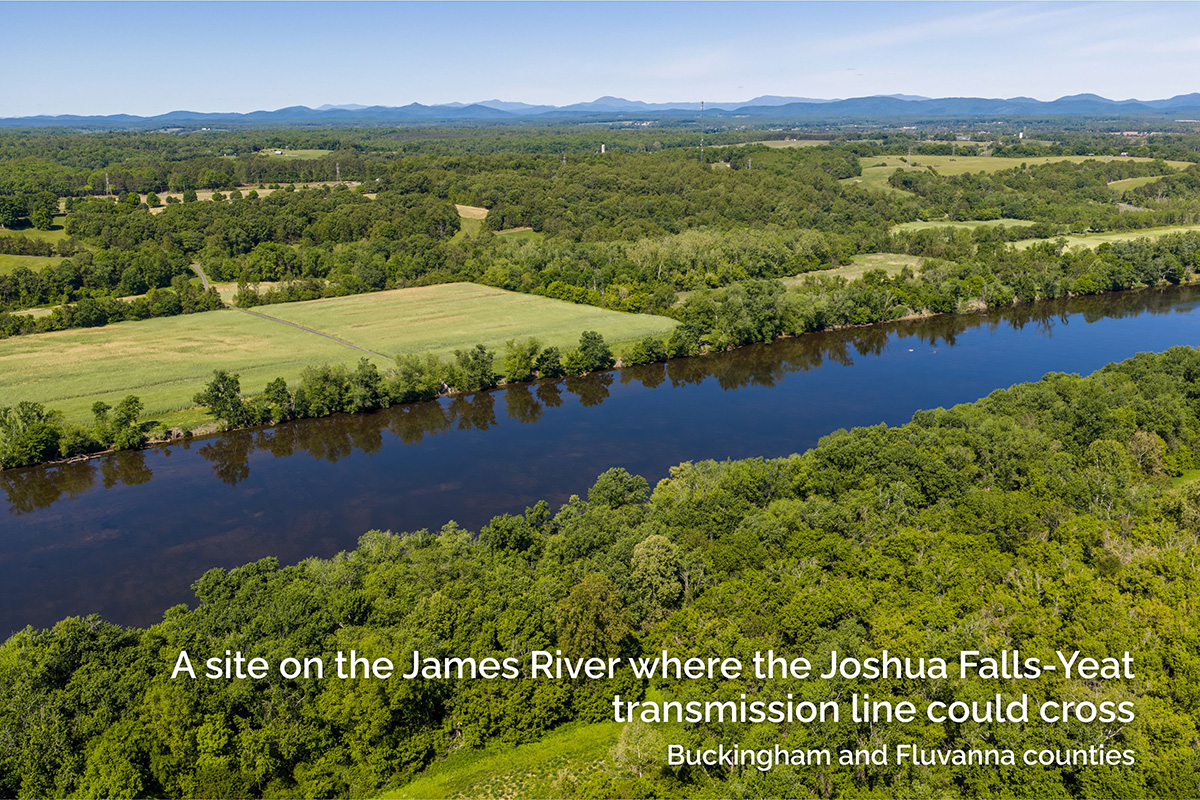
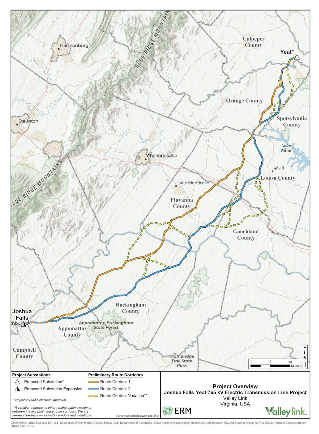
Dubbed the “Joshua Fall-Yeat line” for the substations it will eventually connect, this 115-mile-long, 765 kV transmission line would begin at the Joshua Falls substation in Campbell County, a few miles outside Lynchburg. From there it would head north-east and require a cleared, 200-foot-wide corridor through Virginia’s Piedmont, all the way to heavily forested area near Richardsville in Culpeper County where a large new substation, named Yeat by Dominion, would be needed. Between its Culpeper and Campbell county substations, the line could cut through Appomattox, Buckingham, Fluvanna, Louisa and Orange counties, and possibly Goochland and Spotsylvania. A future line is planned to connect Yeat to the Morrisville substation in Fauquier, and organizations concerned about the impact of the project predict that new and existing lines will be integrated along the corridor to expand delivery to data centers.
WHEN: Tuesday, May 19, 10 a.m.
Light breakfast and coffee will be provided.
WHERE: Historic Germanna, 2062 Germanna Hwy, Locust Grove, VA 22508 (Google Maps)
Historic Germanna’s place along Virginia Route 3 is emblematic of the many varied resources threatened by the Joshua Falls-Yeat transmission line proposal. Its Siegen Forest woods lie within what was the first German settlement in colonial Virginia and were named by the 42 German immigrants who crossed the Atlantic from the Siegerland area of Germany in 1714. A shallow Rapidan River crossing here, still called Germanna Ford, later bore witness to the Civil War as one of few places large groups of infantry and cavalry could cross the river quickly. Siegen Forest saw the Army of the Potomac’s surprise defeat in the Battle of Chancellorsville in 1863 and U.S. Colored Troops fight bravely during the inconclusive Battle of Wilderness a year later.
Germanna Ford today hosts a publicly accessible boat launch, part of the Rapidan-Rapphannock River Water Trail, a navigable “blueway trail” with several put-in and take-out points along the way. Meanwhile, Siegen Forest today holds rich ecosystems of flora and fauna and several archeological sites that provide insight into early German immigrants and 18th century Native American and African American histories on the land. The Joshua Falls-Yeat line would cross the Rapidan River and Virginia Route 3 near the location of the historic Germanna community and Historic Germanna Foundation.
WHY: The Joshua Falls-Yeat transmission line would have tragic consequences for the nine-county region it would traverse, and beyond. The region offers rich historical and socio-cultural resources, environmental treasures, agricultural and forestal resources and tremendous scenic views. These resources are important economic drivers — with minimal fiscal, environmental or land-use impact. Direct visitor spending in the nine affected counties was $677.7 million in 2024.
Numerous historic districts within the path and/or the viewshed of the proposed project would be impacted:
Potential viewshed or other indirect impacts
- Galts Mill Village Historic District
- Buckingham Court House Historic District
- Buckingham Female Collegiate Institute Historic District
- Bremo Historic District
- Fluvanna County Courthouse Historic District
- Green Springs Rural Historic District
- Mineral Historic District
- Fredericksburg and Gordonsville Railroad (Historic), Fredericksburg, Orange and Charlottesville Railroad (Historic), Potomac, Fredericksburg & Piedmont Railroad (Historic), Unfinished Railroad (Historic), Virginia Central Railway Historic District (Historic/Current)
- Trevilian Station Battlefield, determined potentially National Register-eligible
- Mine Run Battlefield, determined potentially National Register-eligible
- Journey Through Hallowed Ground National Heritage Area
Direct impacts
- Orange Springs, National Register of Historic Places Listing, VLR Listing, DHR ID: 068-0066
- Louisa County cemetery off Chopping Road with 16 burials, DHR ID: 054-5044
- Rivanna Canal Navigation Historic District
The potential impacts are enormous. Over 2,600 acres of land that is currently forested, farmed, providing critical wildlife habitat and contributing to the rural economy and character of the region would be cleared and converted to utility right-of-way. Tens of thousands of acres more along the line are likely to face pressure for new development, either for energy generation and storage or for data centers, development not anticipated by local zoning or comprehensive plans.
This is an urgent moment. This project is scheduled to come before the Virginia State Corporation Commission for approval of a final route in September 2026.
Speakers at the press conference from local governments and organizations advocating for the historic, cultural and scenic resources of the region will be providing comments on the impacts from Valley Link and be available to answer questions about next steps.
Residents of the affected counties and other members of the public should submit comments ASAP in Valley Link’s online GeoVoice portal about specific impacts within the path of the proposed routes. Detailed maps are available here. Valley Link will hold another round of community meetings in June, and the community will be able to submit comments to the SCC on the proposed route starting in the fall.
Media Contact: Elizabeth Ransom, Media & PR Specialist, [email protected]; 540-347-2334 x 7029
###
The Piedmont Environmental Council (PEC) works to protect and restore the lands and waters of the Virginia Piedmont, while building stronger, more sustainable communities. Founded in 1972, PEC is a locally based, community-supported 501(c)3 nonprofit and accredited land trust. At the core of PEC’s approach is a focus on educating, engaging and empowering people to effect positive change in their communities.