Gem Bingol, PEC’s Loudoun field representative, delivered the following message at more than ten community meetings across Loudoun County held during February & March 2019. This blog post was developed from her presentation slides and notes:
Hello and welcome. The Piedmont Environmental Council is a 47-year old land use policy and conservation organization. We work in nine Virginia Piedmont counties, with staff on the ground in each one. We believe in the Piedmont’s people and places, and in the power of community partnerships and citizen involvement to ensure better local decision-making. This involvement is critical to maintaining the health, safety and welfare of residents today and into the future.
And we know that if you don’t show up and stand up for what you care about, than it doesn’t really matter that you care.
Partnerships, with individuals and groups, are essential to our work. We’ve been working with the Loudoun County Preservation and Conservation Coalition, the Coalition of Loudoun Towns, the Transition Area Alliance and many other local groups who are strongly engaged and care deeply about the future of Loudoun.
Today, we’re here to talk about the Loudoun Comprehensive Plan. Also known as: “Loudoun 2040,””Envision Loudoun” or “the Comp Plan.”
What’s a Comp Plan? A Comprehensive Plan provides the vision for a County’s future and guides the direction it takes, laying out community values and aspirations. It balances the rights of private property owners with societal goals. Comp Plans are required by Virginia state law. Localities must review them every 5 years, and periodically update them. Loudoun’s last major revision occurred in 2001 with adoption of the current Comp Plan.
The guidance in the Comprehensive Plan determines where development does and doesn’t happen, what kind and how much housing there will be, and the percentage and character of the open space contained within developments. It determines where roads are planned, the presence of transit and trails and other critical community infrastructure. It determines where the nearest stores will be, whether the community will do anything to ensure clean air, clean water, and adequate habitat. Also, whether it will preserve its heritage resources and demonstrate how it plans to become more sustainable.
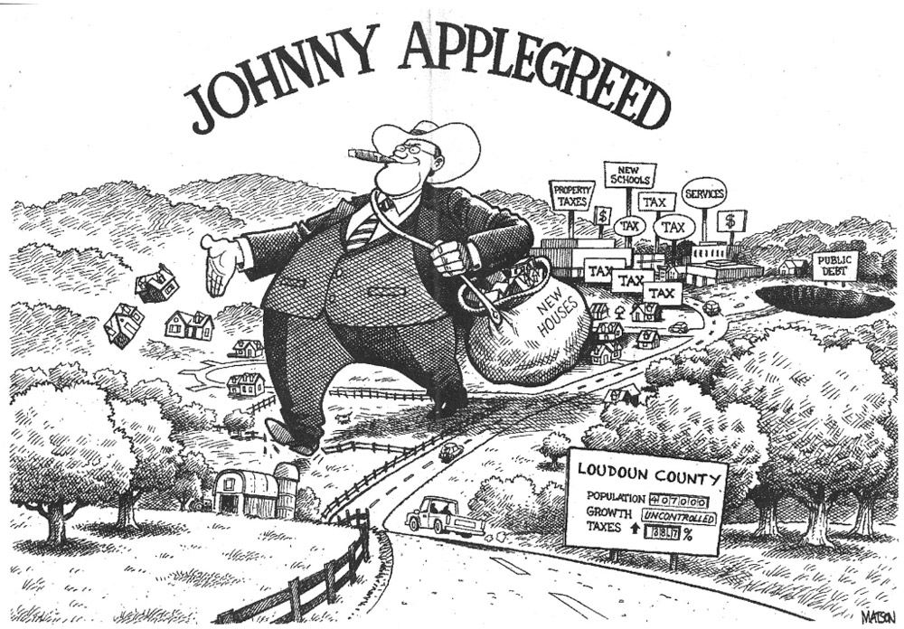
What we all experience as Loudoun County is a direct result of past plans and past decisions by local elected officials. Loudoun is clearly an above-average place to live, but residents have also had to deal with the negative consequences of too much scattered development.
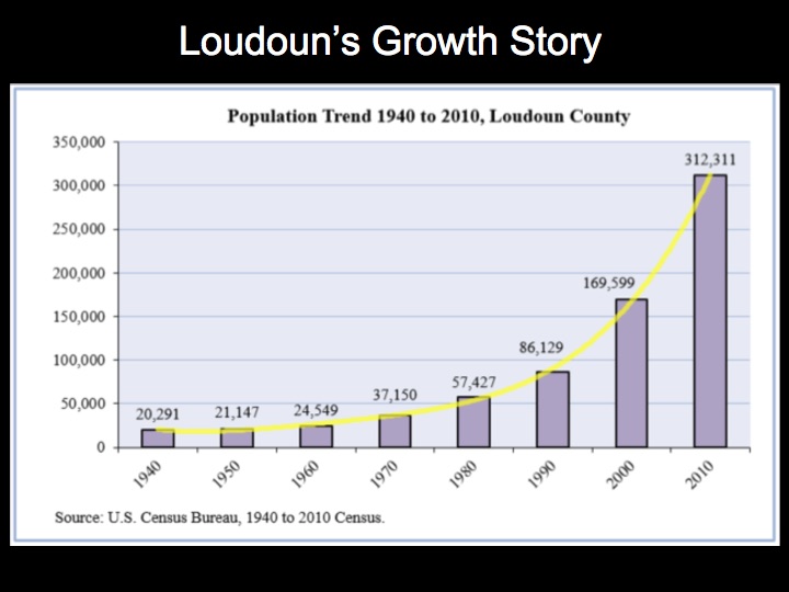
As of 2018, Loudoun’s population was estimated at 402,000.
Let’s dig into Loudoun’s growth history just a bit, to set the stage for how we got here. In the 1960s when our population was around 25,000 people, Dulles Airport was an early catalyst for growth. In the 60 years since, we have more than doubled our population every 20 years.
When you double your population from 1 to 2, it’s not a huge impact in terms of land use, but when you double from 200,000 to 400,000 people in under 20 years, the impacts are broadly felt and unavoidable.
The Comp Plan serves as a guide, accompanied by the Zoning Ordinance which is the law that implements the vision. It provides the specific rules for what the vision in the Plan will look like on the ground.
Here’s the map showing the 3 main policy areas in the current Comp Plan. Suburban, Transition and Rural areas.
And here are some aerial maps to show you how that translates per the Zoning Ordinance:
Suburban Policy Area
This is the 60,000 acre Suburban Area where Loudoun has chosen to focus its growth to date. The density averages between 3 and 4 units to the acre with 30% open space in residential developments.
Transition Policy Area
There are 22,000 plus acres that lie between the Suburban and Rural Policy Areas. The Transition area was intended to visually and spatially separate the Suburban and Rural areas, with less density than the Suburban area, but more than the Rural Area.
It’s easy to see the dividing line in this photo. It was also planned to be more open to protect the natural and historic resources in this area.
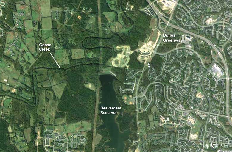
In the northern part of the Transition Area, the plan called for protecting the Goose Creek and Beaverdam Reservoirs, and kept density at 1 unit per 10 acres (clustering allowed) with a 70% open space requirement to limit impervious cover. Limited industrial development was allowed only on the north side of the Greenway.
The Plan also requires 70% open space in the Southernmost section of the Transition Area, which contains headwaters for the Occoquan Reservoir, another major drinking water source for the region.
Since water quality declines as the percentage of imperviousness goes up, the goal was to start with a cleaner, less expensive and more sustainable drinking water supply.
In the rest of the Transition Area, the zoning density is mostly 1 to 3 acres per unit with 50% open space.
Rural Policy Area
The Rural Area has a northern and a southern section, with higher base density of 1 unit per 20 in the north and 1 unit per 40 acres in the south. You can cluster for higher density in both areas, but subdivisions are required to have 70% permanent open space or conservation lots for rural economy uses.
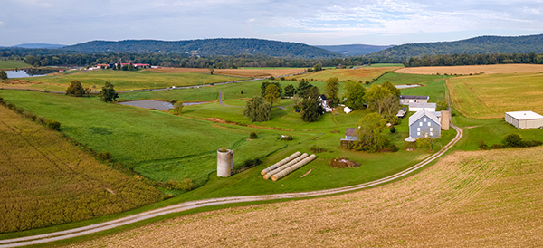
The cluster and large lots mixed in with farms, are planned to keep land open and available for agricultural uses, and to protect the natural resources that help provide clean air and water for Loudoun and the region. Much of the county’s history and heritage resources are also in this area, and we have benefitted from a land stewardship ethic on the part of many residents who live here.
Residents and county officials recognized the value of preserving open lands for agriculture to ensure food security and ecosystem support. The financial benefit is that cows and crops don’t go to school. In fact, the open lands in this huge area provide more in tax revenue than they require in services, so they help to offset the costs of residential development in our growth areas.
So let’s look again at where we are now. The following chart shows where growth has already occurred, and where future growth can happen under current zoning:
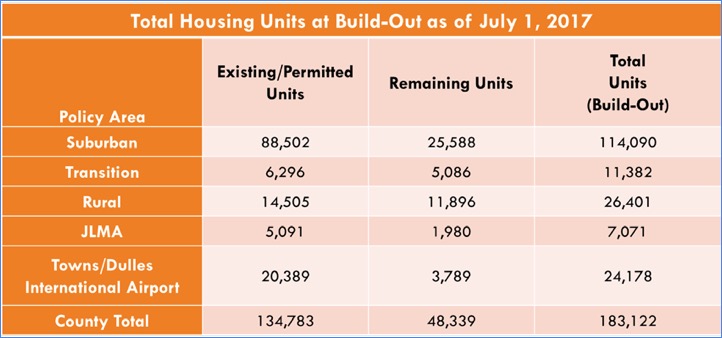
As of mid-2017, we had approximately 134,000 units on the ground—this is what you see when you drive around Loudoun.
In the middle column, what we have is the growth that is allowed to happen under the current Comprehensive Plan and associated zoning. How much growth is that? 48,000 more houses are already approved and/or can be built per our zoning across the county. This number changes with new approvals and additional construction. Since 2017, this number has gone down slightly to 45,292. That is about 1/3rd more units than we have today, with plenty of development potential in each of the three major policy areas.
- Recent buildout number pulled from Tischler Bice analysis found on pg 23 of Item 01 Loudoun 2040 Comprehensive Plan (22MB PDF)
Remember that skyrocketing growth that I showed earlier? Loudoun has been an outlier in the region since the 1990s. We’ve taken more than our fair share of the region’s growth. When our neighboring counties were growing at an annual rate of around 1.5%, Loudoun was growing at 5.1% annually, or triple the rate. Continuing the rates of growth we experienced in the past is NOT sustainable.
If we assume these ~45,000 units are built over the next 20 years, we would have a growth rate that is more on par with the rest of the region—at around 1-1.5% per year.
One thing we’ve been hearing is that Loudoun needs more housing overall, so we can have affordable housing and commercial development (aka high paying jobs).
This is a myth and the proof is on the ground: Despite leading the region and much of the nation in residential growth, we DO NOT HAVE more affordable housing or more high paying jobs.
To get affordable housing and “missing middle” houses, what we need instead are effective housing policies (e.g. a higher percentage of affordable housing required near metro, a larger percentage of multi-family housing, lengthening the time-period that Affordable Dwelling Unit or ADUs stay in the system, etc). There are many aspects to this problem that need to be addressed, and the County has to be a driver—but not to just indiscriminately add more housing. When you look at data on the cost of housing per square foot since the 1970s to today, the main difference doesn’t come from cost per square foot, it comes from doubling the average size of our homes. We must also recognize that affordable housing is a regional and national problem with many causes outside of our control.
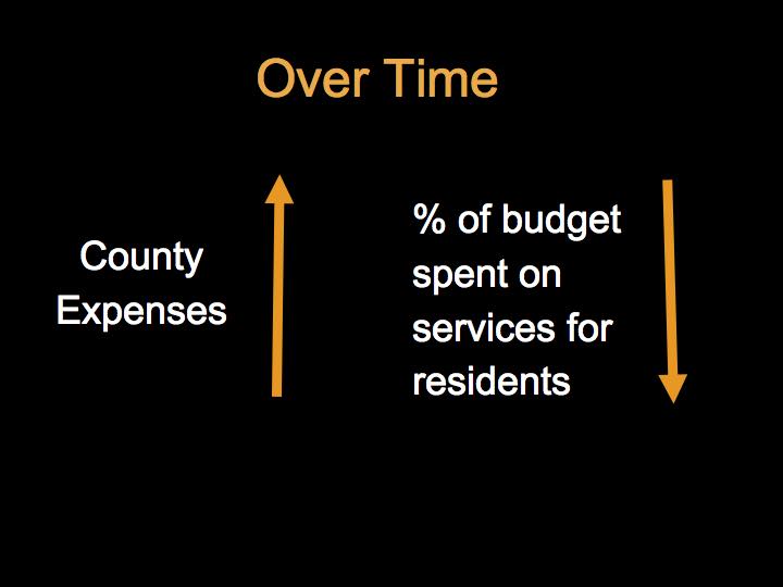
Loudoun Boards have faced and dealt with the need to balance the budget in two main ways:
- 2000-2010: We saw increased taxes.
- 2010-2018: Average taxes paid remained relatively flat due to the County equalizing the residential tax rate. We’ve also seen a decrease in services. The County now spends about 13% less per person on services than it did in 2000.
And while we understand that data centers have helped offset the cost of residential growth, the secret sauce that’s helped Loudoun manage its budget is the excessive growth itself (see Strong Towns: The Growth Ponzi Scheme). It helps to cover today’s costs with more income from the new development and associated taxes, but it begs the question—what about residents’ quality of life?
Is this what we want? It’s not sustainable to keep up this pattern, and the deficit of public facilities and services for residents would continue. The County hasn’t kept up with its own standards, particularly in the suburban area.
Another piece of the picture resulting from our growth and growth pattern is the number of cars and miles we drive today versus in 2000.
Cars per household
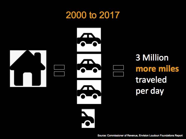
This slide makes two different points.
- For every new household established from 2000-2017, the number of registered vehicles has increased by 3.4 cars on average. This sounds like a lot, but consider that 2 adults generally require 2 cars, and if there are teenagers in the household, they often have a car (or more). The number also takes into account vehicles owned by businesses that service the public.
Our sprawling growth doesn’t give most people the option to walk or bike to work or errands. All of our cul-de-sacs in neighborhoods across the eastern part of the County are not easily serviced by buses. People may have to walk a quarter to half a mile or more just to get out to a major street where a bus route would be manageable.
- In 2000, VDOT data shows that Loudoun residents drove more than 3 Million Miles per day. In 2017, that number had more than doubled, with Loudoun residents driving more than 6 and a half million miles per day. So that means 3 million more miles per day!
This has resulted in a whole lot more pollution and carbon in our atmosphere. And it has meant that Loudoun has had to get into the road-building business, just to keep up. Again, this is NOT sustainable.
Which brings us to the Loudoun 2040 draft…
Back in 2016, the Loudoun Board of Supervisors said they wanted to hear from the public on what will make Loudoun a better place in the future.
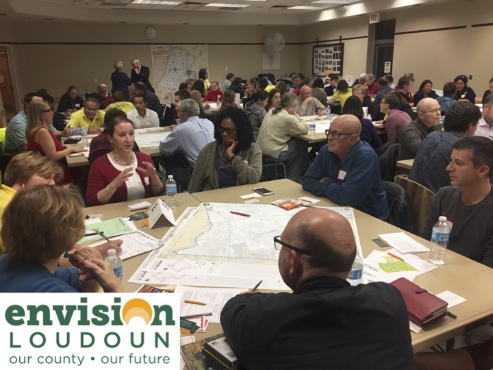
The County set up the Envision Loudoun process, and a stakeholder committee at the same time. There were 3 distinct input sessions scheduled from late 2016 through May of 2018. Following these input sessions, a group of dedicated Loudoun County Preservation & Conservation Coalition members worked together to create an interactive spreadsheet to analyze, categorize and summarize each of the more than 5,000 comments that residents and participants gave in meetings and online.
What emerged was a common set of 4 priorities that held true across the different communities in Loudoun:
 |  |
 |  |
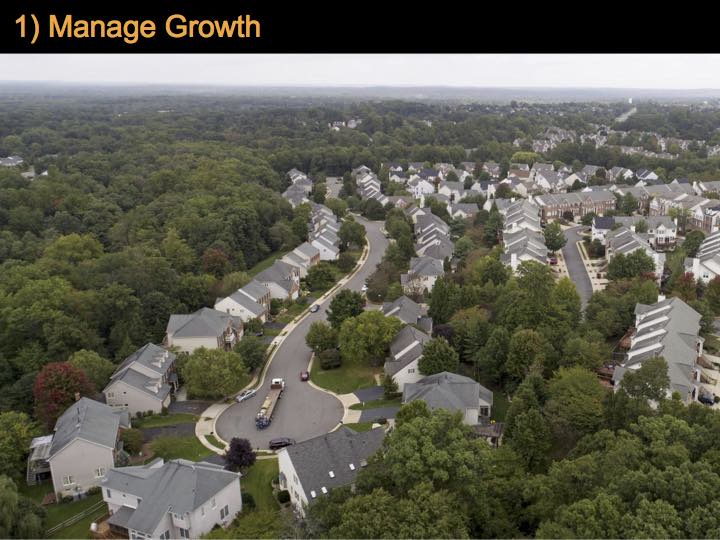
Manage Growth: Loudoun residents want the County to slow the overall rate of development, focus growth at Metro, manage growth in the Suburban area, and maintain the Transition and Rural areas. This starts with removing the additional ~28,500 units that were added to the draft plan.
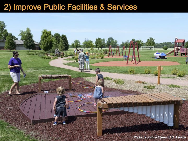
Improve Public Facilities and Services: Loudoun residents want improved transportation options like mass transit and pedestrian/bike connections and traffic calming to improve safety. They also want the County to provide more parks and trails, as well as support for schools and to build other missing facilities.
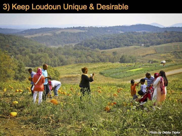
Keep Loudoun Unique and Desirable: Loudoun residents want the County to protect open space to ensure clean air and clean water, conserve our natural resources and local farms, and preserve our cultural assets and historic resources. This starts with maintaining the Transition and Rural Policy Areas.
Responsible Fiscal Management and Accountability: Loudoun residents want the County to keep taxes reasonable, provide missing services, ensure economic diversity to protect against economic shocks, ensure environmental sustainability, and include specific indicators in the plan to demonstrate progress.
So where do things stand?
After a nearly two year process… Loudoun County released an initial draft Comprehensive Plan in May 2018, and a revised version in October 2018.
On Tuesday, March 26, the Loudoun Planning Commission voted to send the draft Loudoun 2040 plan to the Board of Supervisors for review and action.
Are the public’s priorities in the draft? Does it manage growth or perpetuate it?
There are some positive changes in the plan, but these are overshadowed by some clear deficiencies and the scattered growth it envisions. One of those good things: the County has included 4 planning areas, now adding Urban Planning Areas in conjunction with the arrival of Metro. We support this.
However, the following are examples of our specific concerns with the way the County envisions the four policy areas:
Suburban Policy Area
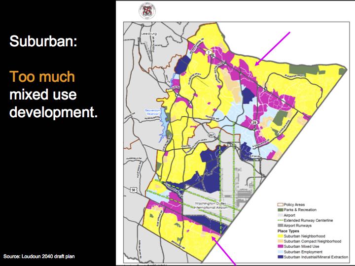
The magenta areas along Rt 7, Rt 28 and Rt 50 have been targeted for more mixed use development. While this sounds good in theory, there has been no analysis of the County’s capacity to provide the needed facilities and services for this much mixed use. Furthermore, in today’s internet world and the shocks of changing real estate expectations, there’s little assurance that the county will get quality jobs or quality retail. And if the commercial businesses don’t materialize, then it’s likely that there will be pressure to switch to more residential growth.
The truth is that the office market has changed. Loudoun was preparing for future high-end employers who never materialized. These days, high caliber employers are seeking sites within a half-mile of Metro stations.
Urban Policy Areas
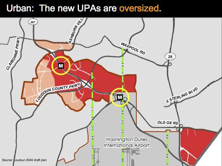
These urban planning areas are good, but oversized, creating a problem in getting development to happen where it’s most desired: within a walkable half-mile around the Metro stations.
It’s helpful to get some perspective on this by comparing our Metro corridor with the Arlington-Ballston-Rosslyn Corridor. The two miles within the Arlington-Ballston-Rosslyn Corridor contains 5 metro stops with a tight focus on development within a half mile (the purple outlines for the half-mile mark) from the stations.
When that corridor is juxtaposed on Loudoun’s Urban Planning Area, it’s easy to see how much falls too far from the stations to be considered a walkable distance.
| Arlington-Ballston-Rosslyn Corridor | Loudoun Corridor |
|---|---|
 | 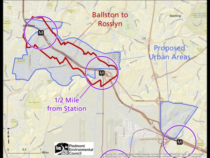 |
Looking at the half-mile circle of land around the three metro stations, you can see that we’ve got to be careful to avoid drowning the area in traffic or drying up demand at the stations. This will take strong phasing requirements and a grid of streets with complete bike and pedestrian facilities in place before the housing goes in. We need additional planning that details the County’s expectations for traffic demand management, affordable housing, environmental protections, energy and stormwater management, etc., with specific guidelines appropriate for each of the three different Metro stations.
Transition Policy Area
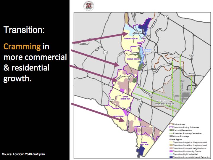
The new plan for the Transition Policy Area is all about growth. This means more traffic added to roads where residents are already sitting in traffic.
It also means industrial and data center sprawl. Instead of limiting industrial development to the north side of the Greenway, now industrial is being planned for much of the sensitive source water protection area between the Greenway and Ryan Rd.
Frankly, this is a plan to eliminate the Transition Policy Area, whether or not the name endures.
I also want to alert you to something that was just inserted into the plan in the final draft. The plan now refers to establishing a Northstar connection to Route 66, prior to approving development south of Braddock Rd. PEC strongly opposes this “Outer Beltway” corridor connection and has for a long time, because it would enable sprawling growth in the area. The highway would cut through local neighborhoods along Northstar Blvd.
Rural Policy Area
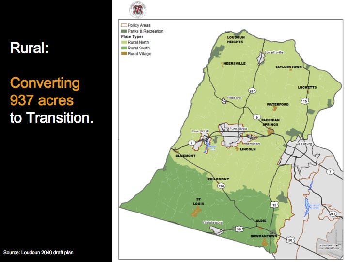
Despite the Board of Supervisor’s stated intention to leave the Rural Area intact, this draft proposes to move rural lands into the Transition Policy Area.
This chipping away at both of these planning areas may seem to be pretty limited BUT, what starts with a trickle turns into a stream if we don’t take care to hold these lines. The pressure is constant. Also, text that supported the use of a full range of conservation tools (i.e. TDRs and PDRs) to reduce development potential in the rural area has been eliminated.
The draft plan is a plan for growth
The latest fiscal impact analysis points to another 28,496 units being added through the new Loudoun 2040 plan, on top of the 45,292 already allowed under the current plan. Together those 73,788 units represent 61% of all existing development–to be built out in the next 20 years!
This comes at a time when County Administrator Tim Hemstreet is projecting far more modest population growth (slide 31/61), completely at odds with what is proposed in the latest Loudoun 2040 draft.
So, what’s behind the increase in housing found in the new draft?
It’s an age-old story. In Loudoun and elsewhere, people have made money by spreading houses further and further into less expensive rural areas.
While there’s nothing wrong with people making money through development, speculation on real estate should NOT be the driving force for Loudoun’s future.
The Comprehensive Plan should set up a different vision, backed up by strong zoning and resolve by the Board of Supervisors to enforce that zoning.
Loudoun is at a crossroads, and there is a better option going forward than what’s outlined in the current Loudoun 2040 draft. We can pursue a path that includes more of the same in terms of development, or choose a new path that focuses on providing a better future for Loudoun residents.
How would we propose to improve the plan and put residents’ quality of life first?
1) Focus Growth
Loudoun needs a more detailed plan for growth in the Urban Planning Areas, and should focus any additional growth (beyond the ~45,000 units already allowed) at the Metro stations.
- Bisnow: Much Was Planned, But Little Is Built as Final Piece of Metro’s Silver Line Approaches Its Debut>>
- AARP: Communities Are Embracing Development near Transit: A Snapshot of Transit-Oriented Development Support across the United States>>
The County has grown faster than the rest of the region for too long. Loudoun should target a sustainable amount of growth at a sustainable pace—which can be done with the units already in the plan. In addition, the County should perform an analysis of office and retail trends and provide more detail on how much land would be needed for associated public facilities. Too much mixed use outside of the Urban Policy Areas (as proposed in Loudoun 2040) would directly compete with growth at Metro.
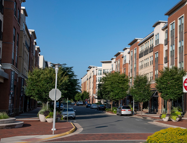
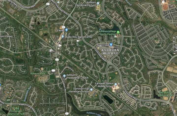
Let’s create a high-quality community where people want to live within a half-mile of the Ashburn Metro Station. This would offer easy mobility by bus, bike and walking and appeals to people who increasingly want to have options for getting around besides driving.
Do you recognize this next image? It shows a development that is in place already and awaiting the arrival of Metro next year. From the closest spot in the picture, the Ashburn station will be less than 1000 ft away (less than a quarter mile!).
What’s the benefit of this sort of development? Here’s a quote from Donna Shafer, Cityline Partners and Bob Duffy, Arlington County Planning Director:
“By 2000, Arlington had seen more than a 100 percent increase in individual development,” Shafer said, and, although the area had “planned for an 80 percent increase in traffic,” the actual rise was only 16 percent. Today, 12 percent of Arlington residents do not own a vehicle, while 40 percent own just one car, Duffy noted. This is possible because more than a third live in one the county’s seven mixed-use, walkable centers along two corridors. Duffy said it took “longevity and commitment, but also understanding that course corrections are necessary.”
Focusing development here will also help to offset the cost of bringing Metro to Loudoun. And focusing Loudoun’s growth like this will make it easier to accomplish other public priorities.
2) Protect our Natural Resources
We need to strengthen chapter 3 of the Comprehensive Plan on natural resources and restore the concept of “green infrastructure.” Text related to green infrastructure is in our current Comprehensive Plan, but has been stripped out of the latest Loudoun 2040 draft. All of the natural resources described in the draft: forests, soils, river and stream corridors, mountainsides and steep slopes, wetlands, etc work together to function as our basic life support system. The current plan provides a guide for siting development around this green infrastructure, because it has greater value the less it is fractured.
The policies, strategies and actions in chapter 3 dictate how the county will manage our natural resources, and need to be strengthened. By protecting and restoring our ecosystems, we will ensure that our watersheds are healthy and green infrastructure is resilient to withstand shocks from a changing climate and impacts of development. Stronger policies will also help protect public and private property from destruction.
3) Provide an Integrated Trail System
Green infrastructure and the developing Emerald Ribbons countywide trail system are mutually supportive. Wildlife and people can both benefit from these interconnections. PEC and other members of the Coalition have worked together to promote this concept to respond to a key public priority. The Emerald Ribbons concept is included in the draft plan and Chair Randall has proposed and co-chaired (along with Supervisor Buona) a Board Member Initiative that the full board has endorsed. The Parks, Recreation and Open Space board is now drafting an implementation proposal for the concept due to the Board in June. This is a long-term effort and residents in each district across the county will be able to guide trail development plans for their area.
4) Increase our Sustainability
Chapter 3 also includes sustainability and energy policies which should be more specific to address the challenges we face. The draft should describe in specific, measurable terms how we plan (for example) to reduce energy consumption, reduce waste, increase water conservation, promote green building, and provide alternative energy sources to power our buildings and vehicles.
5) Keep the Rural Area Rural
The plan should preserve the current boundaries of the rural area and avoid treating rural villages as growth areas.
The appropriate places for growth in the rural area are the towns, not the villages. The towns already have adequate infrastructure with central water and sewer service, whereas the same cannot be said for the historic villages.
The plan should also include language that supports conservation of open land for natural and heritage resource protection as well as for local farms and food security for our community. Permanent open space protections should be included in the plan, with policies that describe the value and use of conservation tools including Purchase of Development Rights and Transfer of Development Rights programs.
6) Maintain the Transition Area
The Plan should preserve the vision and purpose of the Transition area, maintain the current build-out potential and open space requirements, improve source water protections, and eliminate further data center development from the areas south of the Greenway. Data centers should be sited in airport noise zones and in multi-story buildings near the airport, not sprawling out in source water protection areas on sensitive open lands. The Plan should also indicate that permanently conserved, connected and usable open space will be integrated into development plans.
7) Provide Metrics
Finally, the implementation chapter of the Plan needs major revisions to provide measurable indicators by which to gauge progress towards plan goals, i.e. number of streams taken off the impaired waters list, acres of wetlands restored, number of trail miles installed, etc. This would increase accountability and make it possible to highlight successes and focus attention on areas for improvement.
What’s Next?
The 90-day time clock for Board of Supervisors action on the draft plan started on March 26, 2019. The Board will be holding two public hearings in April:
- Wednesday, April 24, 6pm
Board Room, Loudoun Gov’t Center
1 Harrison Street, S.E., Leesburg, 20175 - Saturday, April 27, 9am
Loudoun County Public Schools Administration Building
21000 Education Court, Ashburn, 20148
Starting Friday, April 5, you can sign up to speak at one of these two public hearings by calling the county administrator’s office at 703-777-0200. You must call in for yourself. Speaking time is limited to 2.5 minutes, but there is no limit to the number of speakers.
You can give additional public input throughout April, May and June at any of the regular Board meetings (first Tuesdays and third Thursdays). The Board could make a decision as early as June 20 on whether to adopt the plan. More on the timeline >>
Write to the Board of Supervisors:
It’s important to remember that while the public has given input on the draft plan, the Board of Supervisors hasn’t yet weighed in on it yet. They haven’t reviewed or revised the draft plan, and they are the ultimate decision-makers. They will have the opportunity to correct the plan and ensure that it reflects what the public wants.
Let the Board know you want them to strike proposed increases in residential growth scattered throughout the County. This is necessary so that Loudoun can meet current deficits and manage growth in a more sustainable and accountable manner. Send a letter >>
Other ways to share the message:
We are working with our partners to review and update our recommendations based on the draft as it is revised. Please sign up for email alerts to stay informed as we continue to promote sustainable solutions.
PEC is working on this issue and has provided this presentation because we all want a better future for Loudoun. I know that when we work together for a common cause, we can achieve great benefits for everyone. Let’s raise our voices together and speak clearly and loudly so that Board will hear and respond!
Gem Bingol
Loudoun Field Representative
The Piedmont Environmental Council
[email protected]
Additional Resources:
- Send a letter: Write to the Loudoun Board of Supervisors>>
- View/download the full presentation: Loudoun 2040: More of the Same or a New Path Forward>>
- 3/29/19 Action Alert: Board of Supervisors to Consider Loudoun 2040>>